Midwest rail-fanning road trip through Ohio and Michigan

  • Topic: News 
  • Thread starter jtbell
  • Start date
  • Tags Tags
    Belt Rust
39 replies · 9K views · last reply
Staff Emeritus
Science Advisor
Homework Helper
2025 Award
Messages
16,110
Reaction score
8,627
[This is an old thread. I revived it a year later to add a related factoid.]

Some of you with long memories might remember my western road trip several years ago, from which I posted pictures en route. I don't know how to paste links on my phone, but you can easily find the thread with a forum search.

I'm on the road again, this time to the Midwest, mainly Ohio and Michigan, again mainly for streetcar and other rail fanning, and revisiting places that I was familiar with when I was a kid. And maybe some places that I didn't get around to visiting back then.

Today I started the trip by heading up I-26 and US-23 through western NC, eastern TN, western VA, and eastern KY. Sounds confusing? Look at a map and see how the boundaries run!

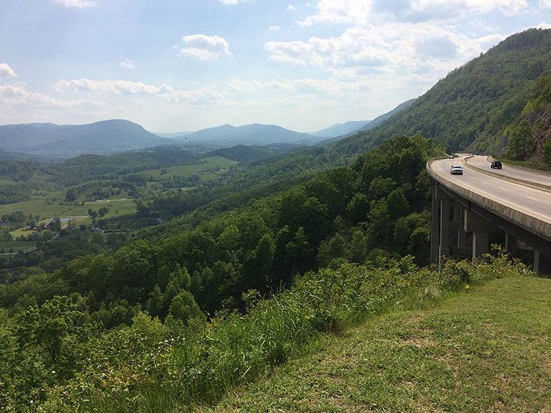
These two pics are from western VA. One is from Natural Tunnel State Park, where early railroad builders saved themselves most of the work of tunneling through a ridge by taking advantage of a pre-existing natural feature.

Tonight I'm in the small town of Louisa KY. Tomorrow I'll head through Ohio to Dearborn MI where I'll spend a few nights.
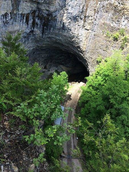
Railway track running out of a large natural tunnel opening in a limestone cliff, with green trees on both sides of the track.


Elevated highway curving along a wooded mountainside, with two cars on the near lanes, overlooking a green valley with farms and distant blue ridges under a partly cloudy sky.
 
Last edited:
  • Like
Likes   Reactions: DennisN, davenn, Drakkith and 3 others
In fact I did see a bit of WV today. It's right across a river from the town where I'm staying tonight. I drove around both towns while looking for a place to eat dinner.

Actually eastern KY is very similar since it too was very dependent on coal for its economy.

One can definitely see that economic conditions have deteriorated. Every town has a lot of empty storefronts. There are billboards all over for addiction and other social services.

People are trying to make tourism a bigger part of the economy. The road I was on for most of the day has been branded as the "Country Music Highway ". Pikeville KY has the "Hatfield-McCoy Feud Historic Site". Etc.

But I suspect this attracts basically a regional audience. This area is way off the beaten track for people in the well-off areas of the northeast and Midwest, let alone the west coast.
 
jtbell said:
One can definitely see that economic conditions have deteriorated. Every town has a lot of empty storefronts. There are billboards all over for addiction and other social services.
A book that I enjoyed very much is about the people in the part of the country you're going through -- "Hillbilly Elegy," by J. D. Vance. He grew up, mostly raised by his grandparents, due to his mother's addiction and her highly unstable marital situation. Doesn't sound very promising, but he praises his grandparents highly for allowing him to break free of the rut that so many of his peers fell into. Highly recommended.
 
Serendipity strikes! Outside Huntington WV I passed an amusement park with a stream of cars and school buses pulling in. Even though they aren't open to the public today (it's one of their May School Days), they let me pay and get in. Probably figured I was one of the teachers or parents or grandparents.

According to Wiki it was built by the local streetcar company in 1903 so it sort of fits with the theme of this trip.

Tall roadside sign for Camden Park showing a clown figure in a red jacket and white ruffled collar beside a red arrow sign reading Camden PARK, with stacked signs reading RIDES, PICNICS and Fun for ALL.

Wooden roller coaster with a train of riders climbing a steep lift hill, viewed from ground level beside a white-railed fence, with two adults and a child watching.

Crowd of children and adults queuing outside a whimsical wooden building labelled Haunted House, with a green fringed awning, a sign reading Camden Park, and a park map on a board nearby.

Aerial view of a miniature golf course with green fairways, stone-edged ponds with small fountains, and a wooden gazebo, beside a green chairlift tower carrying red seats with riders.

Photo of a large amusement park ride with a yellow and red rotating arm, passengers seated on a circular gondola swinging high above a fenced area with a small building and trees behind it.
 
Last edited:
  • Like
Likes   Reactions: dlgoff
My father is originally from Michigan, and I have relatives living in Dearborn, so I saw your post above with a certain degree of interest. I hope you enjoy your road trip, as well as your stay there.
 
I'm in a hotel on Michigan Ave at Telegraph Rd. I didn't have a car until near the end of grad school in Ann Arbor so I drove here only a few times. But I didn't have any trouble getting here. I even remembered the Michigan Left Turn!
 
Pop quiz: What's "missing" from this new Detroit streetcar?

Teal and white QLINE streetcar numbered 289 at a station in Detroit, with a slogan along its side reading 'Used to tell me the sky's the limit, now the sky's my point of view.' Pedestrians wait on the platform.
 
Last edited:
jtbell said:
What's "missing" from this new Detroit streetcar?
That brush thingy on top?
Cartoon illustration of an orange and yellow train engine with a red cow-catcher, with the text "I think I can" on the yellow background.
 
  • Like
Likes   Reactions: DrClaude and davenn
Yep! It runs on battery power for about half its route, and uses an overhead wire elsewhere. At the ends of the route there are charging points.

QLINE streetcar in teal and multicolored livery stopped at a platform beside a pole-mounted overhead wire pantograph, with a CVS storefront and a left-turn traffic signal in view.
 
Last edited:
  • Like
Likes   Reactions: DrClaude, davenn and dlgoff
What would a road trip be without eating at a diner? A short walk down the road from my hotel is "Leon's Family Dining" which in the Northeast or in South Florida would be called just "Leon's Diner". A big clean place, with a huge menu, packed with local residents. I had a Philly cheesesteak omelet for brunch just now.

I walked so much yesterday that my left foot is sore and a bit swollen, so I'm taking it easy today. On my western road trip seven years ago I let it get so bad that I had to cut that trip short. I don't want that to happen this time.

I've read about a good used-CD store in Dearborn, so I'll check it out later today.
 
Last edited:
In Detroit, "Coney Island" means a restaurant that specializes in chili dogs. These are the two oldest Coney Islands, the Lafayette (left) and American (right, with the pointy end). They were founded as a single restaurant by a pair of immigrant Greek brothers, who fell out and split the restaurant into two!

Chili dog on a white plate, topped with meat chili, diced white onion and yellow mustard in a split bun.

Interior of a diner with red-and-white striped walls, black-and-white checkered floor, red chairs and tables, a counter with a glass display case, and a neon sign reading Diamond.

Street view of the American Coney Island restaurant, its facade painted red, white and blue with white panels and a blue awning with white stars, beside a brick building and a glass office tower.
 
Last edited:
  • Like
Likes   Reactions: dlgoff and davenn
This is the former Michigan Central railroad station in Detroit. On one of my day trips from Ann Arbor long ago, I took a train from here to return, instead of my usual bus. Amtrak moved out in 1988, and I think the building has been empty since then. People have come up with various plans for it, but they've all fallen through.

Large abandoned early twentieth-century railroad station with a tall multi-story office tower rising behind an arched stone entrance; green lawn and paved drive in front, overcast sky.

Detroit has a lot of "urban ruins" like this: old automobile factories, etc.

In 1950, Detroit's population was 1.8M. In 1980 (around the time I used to visit), it was 1.2M. Now it's less than 0.7M. So there are lots of abandoned businesses along most of the main arteries, such as Michigan Ave. which I drove along, coming in from Dearborn. The side streets have lots of vacant lots and empty houses, in the outer parts of the city, between the central area and the suburbs.

The central area has actually revived significantly. Tech startups and other information based companies are relocating there, attracted by cheap rents. Old office buildings have been converted to apartments, and new apartments are springing up.

Yesterday I saw lots of people downtown, eating at sidewalk cafes, walking their dogs, kids playing in a new park on the site of the former city bus terminal. All this would have been unimaginable on a Sunday in the 1970-80s. There are new trendy shops next to vacant storefronts, and a lot of construction/renovation activity.

So things are looking up in the center of the city, from downtown about 3 miles out Woodward Ave. to the New Center area at Grand Blvd.

But the rest of the city is still in bad shape. Lots of poverty, and not enough tax money from 0.7M people to provide services for a city built for 1.8M. It seems to me there's going to have to be some kind of contraction, concentrating people into a smaller area so they can be served more effectively.
 
Last edited:
  • Like
Likes   Reactions: dlgoff
I went on a road trip to DC coming from upstate new york last month. Driving through western pennsylvania and Harrisburg (which I found out was the capital of PA when I went through) was a real eye opener. That place puts the rust in rust belt.
 
The Rust Belt

I had to google the term as to its relevance to the USA

The Rust Belt is a term for the region of the United States from the Great Lakes to the upper Midwest States, referring to economic decline, population loss, and urban decay due to the shrinking of its once-powerful industrial sector, also known as deindustrialization. The term gained popularity in the U.S. in the 1980s.[1]

The Rust Belt begins in western New York and traverses to the west through Pennsylvania, West Virginia, Ohio, Indiana, and the Lower Peninsula of Michigan, ending in northern Illinois, eastern Iowa, and southeastern Wisconsin. Previously known as the industrial heartland of America, industry has been declining in the region since the mid-20th century due to a variety of economic factors, such as the transfer of manufacturing further West, increased automation, and the decline of the US steel and coal industries.[2] While some cities and towns have managed to adapt by shifting focus towards services and high-tech industries, others have not fared as well, witnessing rising poverty and declining populations.[3]

I sort of got that from your descriptions, but wasn't totally sureDave
 
Today I visited Ann Arbor, nearly 35 years after finishing my PhD at the U of Michigan. I last visited there 12 years ago.

The physics building, Randall Lab, still looks pretty much like it used to, from the front (first pic). It was expanded considerably at the rear about 25 years ago (second pic), and renovated completely inside so it looks nothing like when I was there.

As I expected, all the profs that I worked with are now retired, listed in the "Emeritus" section of the faculty photo gallery in the hallway.

Brick building with stone trim and tall windows beside a paved walkway, with black lamp posts, a trash can, a planted bed, and leafy trees in sunshine.

Brick university building with curved bay windows on the left, seen across a paved plaza with trees, lampposts and a trash bin reading Zaragon Luxury Apartments.


A couple more views of campus nearby:

Brick building with arched windows and green copper domes beside a paved campus plaza, with students walking, a person working on a laptop at a table, and tall lamp posts under a blue sky.

Campus quadrangle on a sunny day with a bronze letter M set into the pale paving stones in the foreground, brick paths, stone benches with people sitting, and tall trees around a clock tower.
 
Last edited:
  • Like
Likes   Reactions: davenn
You know you're getting old when most of the shops and restaurants that you knew at university are gone or going, and some of them are mentioned on historical markers on the corners of buildings. :H

Sunny street scene in Ann Arbor with the Michigan Theater marquee, a stop sign, cyclists, pedestrians and parked cars, and a brick building on the right.


Ulrich's was where I bought most of my textbooks for grad school. There were once 3 or 4 bookstores in Ann Arbor that sold textbooks. I think this is the last one.

Brick storefront with a sign reading "Ulrich's" and yellow window banners, with people seated at outdoor café tables on a paved plaza in sunshine.


But some things haven't changed. Minnie's Coop is still purple! I think I remember reading that the color is specified in their bylaws.

Three-story purple wooden house with white trim, a brick chimney, and a stone foundation, with a red car parked in front and two black trash bins at the curb.


I also discovered that my favorite German restaurant in Ann Arbor, Metzger's, which I thought had gone out of business when I was here last time, actually moved to a new location just outside town. So I went there for dinner before driving back to Dearborn.

Interior of a German-themed restaurant with dark wooden chairs and tables, patrons seated in booths, shelves of steins and clocks, and wall crests and framed pictures.
 
Last edited:
  • Like
Likes   Reactions: davenn and dlgoff
Yesterday I crossed an item off my bucket list: Put-in-Bay, a resort village on an island in Lake Erie. First you take a half-hour ferry trip.

Passengers walking up a boarding ramp toward a white-and-blue ferry with orange life rings on its upper deck, labeled PUT-IN-BAY, under a clear blue sky.

View from the stern of a ferry looking back toward the wake, with its gray loading ramp raised and yellow edging, and two people walking on the deck.


Then to get to the village about 2.5 miles away you bring your car over on the ferry (expensive), rent a golf cart on the island (also expensive), rent a bicycle (rental place not open for the season yet), or take a converted school bus that shuttles back and forth ($2.50), or walk (which I did because it was a nice day).

Two people ride in a golf cart on a sunny tree-lined road with cracked asphalt and a white center line, a red fire hydrant on the right.


The big historical thing there is a monument to the naval Battle of Lake Erie in the War of 1812, in which the US defeated Britain. Every kid in Ohio learns about this in school, or at least did when I was in school. There's a nice view from the top of the monument, but unfortunately it isn't open for the season yet.

Perry's Victory and International Peace Memorial: a tall white stone column topped with a bronze urn, rising above lawns and trees beside a road and a small lake.


Fortunately the local historical museum opened on Monday. Even some of the restaurants weren't open yet. It's a bit early in the year. In a couple of weeks the island will probably be full of visitors. Lots of rental apartments, cottages and bed & breakfast places.

Street view of the Boardwalk entrance arch over a road, with a view of the lake and a bench on a grassy lawn beside a sidewalk.


Back on the mainland, across the road from my hotel in Port Clinton is an unpretentious fast-food style restaurant that specializes in fried lake perch and walleye. I couldn't decide which one, so I had the combo platter that has both, with a pile of onion rings. Mmmmm. :biggrin:
 
Last edited:
jtbell said:
Then to get to the village about 2.5 miles away you ... walk (which I did because it was a nice day).
jtbell said:
There's a nice view from the top of the monument, but unfortunately it isn't open for the season yet.
bold by me

I would think "fortunately it isn't open"; after 2.5 mile walk, how many steps to the top of the monument? Nice pics. :)
 
I've gotten behind. First I left my phone charger in the hotel in Port Clinton and didn't realize it until my battery had nearly run down. I had to conserve battery power until I could buy a new charger. Then I spent an evening visiting a friend.

Just after leaving Port Clinton I came to Lakeside, a sort of religious / educational summer colony associated with the Methodist church. During the "season" day-trippers have to pay an entrance fee at the gate, but that hadn't started yet so I could just drive in, park, and look around.

Blue wooden entrance arch with a gabled top, a cross on a pole above, and the sign reading Lakeside Chautauqua, with a silver car driving through on a paved road.

Street view of a row of white wood-frame houses with gabled roofs and green-trimmed dormers, beside a road with parked cars, a red Stop sign and a Do Not Enter sign.

Green lawn beside a paved path along a lakeshore, with red Adirondack chairs and a red table on the grass, a row of colorful benches, a white house at left, and calm grey water with rocks at right.


Hoover Auditorium holds 3000 people and is used for religious services, lectures and musical performances.

Interior of Hoover Auditorium at Lakeside, Ohio, showing rows of wooden chairs facing a stage with a red curtain, under a long arched wooden truss roof.


Except for the cars and clothing, I suspect the place looks much as it did in the 1920s. If you Google for "lakeside Ohio" and "Chautauqua" you'll get some more background.

A bit further on I came to Johnson's Island which was used as a POW camp for Confederate officers during the Civil War. Nowadays the island is a gated private community, but outsiders can visit the camp's cemetery by paying a toll for the causeway that now connects the island with the mainland.

Rows of white marble headstones standing in green lawn beneath tall shade trees, with a bronze statue of a standing soldier and a lake visible in the distance.


All that took up the morning on Wednesday. Then I headed east past the Cleveland / Akron area to my hometown which I'm using as a base for northeast Ohio and maybe Pittsburgh.
 
Last edited:
I've mentioned occasionally that I did my undergraduate at a small liberal arts college in the Midwest. Well, here it is. On Thursday I drove over to my alma mater, Hiram College. Graduation was last weekend so the campus was pretty quiet, but I did find one of the physics profs in his office. I introduced myself and we chatted a bit. He arrived long after I left and I had never had a chance to meet him.

The physics offices are in a new building, but the classrooms and labs are still in the basement of the old building.

Brick college building with white stone trim and tall windows, a shrub and stone steps leading up to a side entrance, and a paved path under leafy trees.


This classroom is where I had my freshman intro physics course, using Halliday & Resnick as the text. The furniture and projection monitor are new but the blackboard is the same!

Empty classroom with a long chalkboard along the back wall, a ceiling projector, rows of grey desks with chairs, and a wooden door on the right.

Long, narrow corridor with white cinder-block walls, speckled floor, and a row of ceiling lights receding into the distance; bulletin board on the left, doors on both sides.


Trees have grown so much that it's hard to get decent pictures of campus now, when they're in leaf.

Paved walkway curving through a green lawn on a college campus, lined with mature shade trees, a black lamppost on the right and brick buildings at the edges.
 
Last edited:
  • Like
Likes   Reactions: davenn, dlgoff and Borek
Yesterday I crossed another item off my bucket list: I went to a Cleveland Orchestra concert in their renovated home, Severance Hall. I was last here 42-43 years ago when I was an undergraduate. Back then they had covered up the original stage decor with some kind of white or gray acoustic paneling. Now it's back to its as-built state.

As with most of their Friday concerts, this was at 11am instead of the evening, so I didn't have to spend more than an hour driving "home" in the dark.

Front view of Severance Hall, a stone concert hall with a pedimented portico of tall columns and the name SEVERANCE HALL inscribed on the frieze.

Interior lobby of a grand hall with gold-leaf ceiling, red marble columns, gilded balcony railings, and a sweeping staircase, with visitors standing and walking across a patterned floor.

Art Deco mosaic panel set between red marble pilasters, showing a seated robed figure beside a standing woman in a blue gown who strikes a large bell suspended from a red canopy frame.

Interior of Severance Hall in Cleveland during a concert, with an orchestra seated on stage in front of an ornate Art Deco proscenium and pipe organ, and an audience in the seats below.


Across the street is Case Western Reserve University where I passed this historical marker:

Ohio Historical Marker titled The Michelson-Morley Experiment, brown and gold sign on a stand in front of a tree, with paragraph text and a 34-18 marker number.
 
Last edited:
  • Like
Likes   Reactions: Astronuc, davenn, OmCheeto and 1 other person
After the concert on Friday I took the bus downtown and walked around.

Cleveland's signature building was formerly known as the Terminal Tower because it was the main railroad station. Now it hosts only local rail transit lines (the "Rapid") and is known as Tower City, with a shopping mall surrounding the rail station.

Plaza with paving stones and two glass-and-stone light pillars in the foreground, with the stepped Terminal Tower rising in the background beside a stone building on the left and a brick office building on the right.


On the lakefront, from left to right, the Amtrak station with a local light-rail "Rapid" train in front, the Great Lakes Science Center, and the Rock and Roll Hall of Fame.

Light-rail train on tracks in front of a station platform, with a large white museum building with a dome and a wind turbine behind, beside a parking lot and Lake Erie.


If you've seen the movie "Christmas Story" you may remember the scene in Higbee's department store. Although the movie was set in the fictional Hohman, Indiana, the scene was filmed in the real Higbee's in Cleveland, next door to Terminal Tower. (My mother and I always went there on our visits to Cleveland when I was a kid.) Alas, the store is gone. The building is now a casino, but plaques remind of its previous life.

Red awning reading JACK CASINO over a large window with gold trim and curtains, on a pale stone building facade; a small plaque beside it reads The Higbee Company.


I then set out across the Lorain-Carnegie Bridge which spans the Cuyahoga River valley, watched over by the Guardians of Traffic (not to be confused with the Guardians of the Galaxy) at both ends.

Art Deco stone pylon on a bridge, carved with a large relief figure of a robed man holding a bundle, with a stadium and city buildings in the background.


Most of the industry that used to be in the valley has now disappeared, but it's still an interesting view.

View across the Cuyahoga River toward downtown Cleveland's skyline, with the Terminal Tower's stepped tower and other high-rises behind a green steel lift bridge and parking lots.

Elevated view across the Cuyahoga River toward downtown Cleveland, with a tall white tower, a steel lift bridge at right, an arched truss bridge at left, and brick industrial buildings in the foreground.

Wide view over a cleared industrial lot of sand, gravel and rubble along a river, with a concrete grain silo, a steel truss bridge with a lift span, an elevated highway, and downtown buildings beyond.


On the other end of the bridge is the Ohio City district which was once a separate city. Its anchor is the West Side Market which to me looks a bit like a German railroad station outside, but smells rather different inside. :-p

Street view of a brick-paved road lined with trees and lampposts, leading toward a large stone station building with a tall clock tower and a green copper dome.

Interior of the West Side Market in Cleveland with a barrel-vaulted brick ceiling, rows of meat counters including Foster's Meats, Jim's Meats and Pierogi Palace, and shoppers walking the aisle.
 
Last edited:
  • Like
Likes   Reactions: davenn
jtbell said:
...the classrooms and labs are still in the basement of the old building.

The classroom below is where I had my intro physics course,
These excellent photos take me back to my undergraduate physics day. Some of the best times of my life. Thank You for sharing.
 
PIEROGI PALACE made my day :)
 
  • Like
Likes   Reactions: dlgoff and fresh_42
Yesterday (Sunday) I drove around the rural part of northeast Ohio, stopping in some of the villages.

Bristolville:

Village green with a row of small American flags along a curved path, a brown historical marker reading Ohio's First Civil War Monument, and a white church steeple behind.

White clapboard building with a gabled roof and a sign reading CONGREGATIONAL CHURCH above the central door, with a bench on the lawn in front.


Mesopotamia ("Mespo" to the locals):

Village green with a white church with a bell tower, a white outbuilding on the right, and a picnic shelter on the left labeled MESOPOTAMIA TWP., with grass and mature trees.


Andover:

Overcast main street of a small town with a red brick storefront on the left, an Andover Bank sign showing 65 degrees, a pickup truck driving toward the camera, and a grassy green with large trees on the right.


If these village greens remind you of New England, that's no coincidence. This area belonged to Connecticut until 1800, as the Connecticut Western Reserve, and many of the first settlers came from that state. Even some of the larger towns have retained their village greens.

Cleveland's Public Square:

Public square in Cleveland with a grassy lawn, young trees and a tall column topped by a statue; a person sits on the grass in the foreground, and office towers stand behind.


Warren's Courthouse Park:

Street view of a tree-lined town square with a historic stone courthouse with a copper-roofed clock tower and an American flag, traffic lights, and parked cars.


Youngstown's Central Square (a bit too small IMO):

Wide view down a tree-lined city street with traffic lights, lamp posts, and tall masonry and glass office buildings on both sides under an overcast sky.
 
Last edited:
  • Like
Likes   Reactions: dlgoff
The Amish of Pennsylvania are well known, but there are a significant number of them in Ohio, too. Some villages have special parking spaces for them.

Photo from behind a car of a horse-drawn buggy with a black enclosed top and a red-and-white triangular slow-moving vehicle sign, travelling along a two-lane road with yellow centre lines and white edge lines between green roadside trees.

Small-town park with a white octagonal gazebo with a dark shingled roof on a lawn, a black metal rail fence, a dirt road, and a sign reading BUGGY'S ONLY NO CARS.


Like in New England, there are covered bridges. This one near Harpersfield is the longest one in Ohio.

Covered wooden bridge with a dark shingled roof crossing a river over a stone pier, beside a green steel truss bridge, with a small weir and rocks in the foreground.


The Lake Erie shore is lined with beach-cottage colonies. My grandfather built a cottage in one of these.

Wet residential street after rain, with small single-storey houses on both sides, a utility pole with a yellow CAUTION sign, and overhead power lines under an overcast sky.


When I was a kid, Geneva-on-the-Lake was the place to go for fun while we were at the lake for the weekend. It went downhill for a while but now seems to be coming back a bit. As in Ann Arbor there are historical markers about vanished attractions, like Kiddieland with its miniature train ride.

Wet street in a resort strip with a blue sign reading "Geneva on the Lake Public Golf Course" and "Golf Course Al Mraz Dr.", beside a red "Time Square Restaurant" building, parked cars and a Mini Golf booth with a Hot Dogs sign.

Entrance to an indoor amusement arcade with coin-operated games, including a Skee-Ball style lane and machines with colorful lights, under a marquee of lightbulbs, with a few people inside.
 
Last edited:
On Tuesday I made a day-trip to Pittsburgh, which has one of the most spectacular geographical situations among US cities. Top 5? Top 10? Whatever.

Elevated view of a downtown skyline beside a wide river, with a yellow arch bridge crossing it, a fountain on a point at left, and a red funicular car on its track in the foreground.


Its two remaining funicular railways ("inclines"), of which there were once about 15, are landmarks of transportation engineering.

Duquesne Incline: red-brick station building beside a steep track climbing a wooded hillside, with two red cars on the incline and a red footbridge at left.

Red brick station building with a steep funicular track rising up a wooded hillside behind it, and a small car on the incline.


Down at the "Point", you can stand next to the fountain, with the Monongahela River coming in on your left, the Allegheny River coming in on your right, and the Ohio River going straight away from you underneath the bridge to the left of the fountain.

Large fountain jet rising from a circular basin on a river, with a plaza of paving stones in the foreground and wooded hills and a bridge across the water behind.


Near here is the Fort Pitt Block House, built by the British army in 1764, making it one of the oldest structures west of the Appalachian Mountains.

Small brick block house with a hip roof of wooden shingles, set behind a black iron fence, with a flagpole and a gate with a ship's wheel ornament at the right.


The hilly neighborhoods just across the rivers from downtown have seen some revival in the past few decades.

Residential street of brick paving on a steep hill, with parked cars on the left, houses with stone and wooden front stairs, and landscaped terraces with retaining walls on the right.


Steel mills made Pittsburgh great, but now they're gone, or mostly gone. Healthcare industries and education now dominate the economy.
 
Last edited:
  • Like
Likes   Reactions: davenn and dlgoff
On Wednesday in Youngstown I visited the Historical Center for Industry and Labor, which is basically a museum about the steel industry in the Mahoning Valley. This was the second largest steelmaking center in the US, after Pittsburgh.

Map titled Youngstown Steelmakers 1950 showing plant locations of steel companies across Warren, Niles, Youngstown and Sharon, with a legend listing the plants and a scale in miles.

Museum exhibit of a mill worker in a hard hat and goggles beside a yellow-railed platform, with a sign reading GOGGLES AND HATS ARE REQUIRED IN THIS DEPARTMENT and large coiled cable reels at right.


Most of the people working in those mills were immigrants who poured into the region around 1900-1920.

Historical sign reading EMPLOYMENT OFFICE, THE YOUNGSTOWN SHEET AND TUBE CO., with a warning to be careful to avoid injury and a notice in English, Hungarian, Italian, German, Serbo-Croatian and Romanian, signed W.C. REILLY, GEN'L. SUP'T.

Map of Youngstown ethnic neighborhoods in 1930, with a river curving through the city and green-outlined areas labeled Irish, Italian, Jewish, Polish, Hungarian, English, German, Slovak, Greek, Russian and Slovak, with highways and a north arrow.


In a span of four years, 1977-1981, five major steel mills closed. The others eventually followed.

During 1930-1950 Youngstown's population was about 170K. Now it's about 65K. This was once one of the better neighborhoods:

Street view of boarded-up and vacant houses on a rainy day, including a two-story brick house with a white columned porch, a yellow clapboard house and a brick apartment building, with overgrown lawns.

Tree-lined residential street with large older brick houses on the left, their front yards overgrown with tall grass and weeds; the asphalt road curves ahead and a utility pole stands on the right.


The biggest employer now is probably Youngstown State University. Some former office buildings in nearby downtown are being converted into apartments marketed to students, including the former Erie Lackawanna railroad station. The tracks that used to run behind it were probably taken up about thirty years ago.

Six-story brick commercial building with rows of windows and a raised tower on the roof, green awnings at street level, and parked cars in the foreground.
 
Last edited:
  • Like
Likes   Reactions: dlgoff