Cool Geology Pictures
- Thread starter BillTre
- Start date
Join the discussion
Registration is free. Ask a follow-up in this thread, or start your own.
23 replies · 5K views
Earth sciences news on Phys.org
Discussion
- 13,929
- 16,815
Columnar basalt.

This is the Giant's Causeway in Ireland, and is not a photo I took. I did take photos of columnar basalt in Iceland (none quite as impressive as this one, I must admit), but I don't know where they are.
Essentially what happens is that solid but still hot rock cools and shrinks, which builds up tensile stress. It can relieve the stress by cracking, and depending on the material properties you can get a lot of T or Y shaped junctions, which ends up yielding fairly regular columnar prisms, most (but not all) hexagonal.
This is the Giant's Causeway in Ireland, and is not a photo I took. I did take photos of columnar basalt in Iceland (none quite as impressive as this one, I must admit), but I don't know where they are.
Essentially what happens is that solid but still hot rock cools and shrinks, which builds up tensile stress. It can relieve the stress by cracking, and depending on the material properties you can get a lot of T or Y shaped junctions, which ends up yielding fairly regular columnar prisms, most (but not all) hexagonal.
Point Conception
Gold Member
- 1,187
- 1,971
Morro Bay This is the core of a volcano and an easy climb to top.

Last edited:
Point Conception
Gold Member
- 1,187
- 1,971
Simalan Islands


Point Conception
Gold Member
- 1,187
- 1,971
Island off Chumphon, Gulf of Thailand

- 20,819
- 28,467
Impact crater in Germany
Width: 20-24 km
Area: 350 sqkm
Depth: 100-150 m
Date: -15 million years
Remark: has an inner wall
Asteroid size: 1.5 km
Asteroid speed: 20 km/s
Source: https://de.wikipedia.org/wiki/Nördlinger_Ries
Last edited:
Mentor
- 38,154
- 10,762
Regarding the K-Pg boundary mentioned in post #1, I had first heard it described as the K-T boundary, apparently its former name. It is the boundary between the Cretaceous and Tertiary Periods. The term cretaceous denotes chalk (Latin creta) and the letter K derives from the German equivalent, Kreide.
The K-Pg boundary is noted for its high concentration of iridium, much higher than normally found on Earth, but present in higher concentrations on asteroids and such. One hypothesized cause for the much higher-than-normal concentrations of iridium throughout the world in the K-Pg layer is the asteroid that created the Chicxulub impact crater on and near the Yucatan Peninsula in Mexico about 66 million years ago.
The K-Pg boundary is noted for its high concentration of iridium, much higher than normally found on Earth, but present in higher concentrations on asteroids and such. One hypothesized cause for the much higher-than-normal concentrations of iridium throughout the world in the K-Pg layer is the asteroid that created the Chicxulub impact crater on and near the Yucatan Peninsula in Mexico about 66 million years ago.
- 20,819
- 28,467
Not really a single photo, but sintering doesn't have to happen vertically. Here are some nice pictures of the various forms. I considered pasting them all here, but a single click is easier.


I remember that I have seen almost horizontal tiny channels formed by the capillary effect on a TV show, but I couldn't find pictures.
https://gasselhoehle.at/tropfsteine.html
(The site has an English version, but there are more pictures in the German version.)
https://www.showcaves.com/english/explain/Speleothem/Helictite.html
I remember that I have seen almost horizontal tiny channels formed by the capillary effect on a TV show, but I couldn't find pictures.
https://gasselhoehle.at/tropfsteine.html
(The site has an English version, but there are more pictures in the German version.)
https://www.showcaves.com/english/explain/Speleothem/Helictite.html
Last edited:
- 13,929
- 16,815
A friend had this cartoon on a gag-a-day calendar or something like that:Mark44 said:The K-Pg boundary is noted for its high concentration of iridium, much higher than normally found on Earth, but present in higher concentrations on asteroids and such. One hypothesized cause for the much higher-than-normal concentrations of iridium throughout the world in the K-Pg layer is the asteroid that created the Chicxulub impact crater on and near the Yucatan Peninsula in Mexico about 66 million years ago.
I cracked up when I saw it, and then had to explain the joke to him.

- 13,929
- 16,815
To drag myself back on topic, another thing I've seen in real life but don't have good photos of:
 This is on the north coast of Arran. The things that look like funny tire tracks that the guy is pointing at (if you're on a phone you might need to zoom in a bit) are actually fossilised tracks of a millipede that had its left and right feet about eighteen inches apart.
Wiki article (from whence came the photo above).
Wiki article (from whence came the photo above).
difalcojr
- 459
- 352
Pine Creek Mine, outside of Bishop, California, in the Sierra Nevada Mountains, elev. 8100 feet at main mine entrance, which is at the higher level road, above the mill, hidden behind the tree on the left in the photo. Tungsten, molybdenum, some copper, very little silver, gold mined. Scheelite is a white, calcium tungstate mineral with the chemical formula CaWO4. It was called Union Carbide's "gold" mine due high W value. Mine and mill employed around 400. Closed in 1982.
Enlarged area of first photo from above.
From: https://pubs.usgs.gov/bul/0931e/report.pdf : the geology:
"A large segment of the septum of metamorphosed sedimentary rocks, called the "Pine Creek pendant" extends from Wheeler Crest south to Horton Creek, This pendant, 5t§- miles long and about 1 mile wide at the maximum, is exposed in the deep trench of Pine Creek down to an elevation of 7,500 feet, more than a mile below its highest points."
tailings ponds unseen from road coming up Pine Creek canyon.
https://www.jsginc.com/2022/01/18/12-little-known-facts-about-the-historic-mine-in-the-sky/
https://bishopvisitor.com/ghost-mine-in-the-sky/ video of mine today is included on this site.
Shocking! I had no idea, I worked there in 1982 until it closed. The main ore zone inside the mountain, at about 9600 feet up to 11,000 feet, about a mile in length and up to 150 feet wide, is mostly mined out. The inside was a steady 42 degree F., always wet, dripping from snowpack on surface. In ruins now.
Last edited:
Point Conception
Gold Member
- 1,187
- 1,971
Yes ^^ Amazing geography along CA .Hwy 395. Eastern Sierras

Science Advisor
Homework Helper
- 9,615
- 4,838
Big Bend has a wide variety

 .
.
difalcojr
- 459
- 352
Devils Postpile, about 20 miles north of the Pine Creek Mine as the crow flies. At location of head waters of the San Joaquin River that goes down into the Central Valley of California. The Eastern Sierra Nevada Mountains are really beautiful.Ibix said:Essentially what happens is that solid but still hot rock cools and shrinks, which builds up tensile stress. It can relieve the stress by cracking, and depending on the material properties you can get a lot of T or Y shaped junctions, which ends up yielding fairly regular columnar prisms, most (but not all) hexagonal.
The formation of the Devils Postpile began with a volcanic eruption that occurred approximately 80,000 to 100,000 years ago in what is now the eastern Sierra Nevada Mountains of California. During this event, basaltic lava flowed from a vent in the Earth's crust, creating a lava lake that reached depths of up to 400 feet. As the lava cooled, it contracted and cracked, forming the distinctive hexagonal columns characteristic of columnar basalt formations."
- 20,819
- 28,467
Not far from where I live.

I even remember the controversy some decades ago, when paleontologists had to fight hard to preserve it (Grube Messel, oil shale).

That's their most popular find ...

... a little horse, or what someday became horses. Hundreds of other fossils were discovered, from land and sea, and some with feathers. Have a look at all the pictures:
https://de.wikipedia.org/wiki/Grube_Messel
https://en.wikipedia.org/wiki/Messel_Formation#Messel_pit
I even remember the controversy some decades ago, when paleontologists had to fight hard to preserve it (Grube Messel, oil shale).
That's their most popular find ...
... a little horse, or what someday became horses. Hundreds of other fossils were discovered, from land and sea, and some with feathers. Have a look at all the pictures:
https://de.wikipedia.org/wiki/Grube_Messel
https://en.wikipedia.org/wiki/Messel_Formation#Messel_pit
difalcojr
- 459
- 352
How little is little? Wish there was a (required) ruler underneath to give this.
Never saw oil shale before or in an open pit. Interesting looking. Doesn't look like too big a clean-up mess of it. Was it a clean mine operation? I was stationed in Wildflecken for 9 months. Hessen is really beautiful.
Here's one more from Eastern Sierra Nevada, just out of Bishop, coming from the Long Valley caldera eruption 760,000 years ago. About 20 miles from the Pine Creek Mine down in the Owens Valley.

Photo showing two layers of Bishop tuff, eastern California, United States. This outcrop is exposed in a rock quarry in Chalfant Valley about 25 km southeast of Long Valley Caldera. The two main units of the Bishop Tuff deposit are visible here: (1) the lower 5 m of the section consists of the pumice that fell to the ground (airfall pumice) downwind from the eruption; and (2) the upper 5-6 m of the section consists of the basal part of the pyroclastic flows that swept at hurricane speed away from the eruption. The thin dark "layers" just below the contact between the units are stains from an ancient groundwater table (manganese oxide stains).
Never saw oil shale before or in an open pit. Interesting looking. Doesn't look like too big a clean-up mess of it. Was it a clean mine operation? I was stationed in Wildflecken for 9 months. Hessen is really beautiful.
Here's one more from Eastern Sierra Nevada, just out of Bishop, coming from the Long Valley caldera eruption 760,000 years ago. About 20 miles from the Pine Creek Mine down in the Owens Valley.
Photo showing two layers of Bishop tuff, eastern California, United States. This outcrop is exposed in a rock quarry in Chalfant Valley about 25 km southeast of Long Valley Caldera. The two main units of the Bishop Tuff deposit are visible here: (1) the lower 5 m of the section consists of the pumice that fell to the ground (airfall pumice) downwind from the eruption; and (2) the upper 5-6 m of the section consists of the basal part of the pyroclastic flows that swept at hurricane speed away from the eruption. The thin dark "layers" just below the contact between the units are stains from an ancient groundwater table (manganese oxide stains).
Last edited by a moderator:
- 20,819
- 28,467
Early horses were significantly smaller than modern horses, reaching a shoulder height of about 30 to 35 cm. They were roughly the size of a German Shepherd or a cat and weighed approximately 5 to 6.5 kg. These early horses lived in forests around 50 million years ago.difalcojr said:How little is little? Wish there was a (required) ruler underneath to give this.
About 100 acres, if I did the conversion right (40 ha).difalcojr said:Never saw oil shale before or in an open pit. Interesting looking. Doesn't look like too big a clean-up mess of it.
Yes, a former oil shale mine. And if I remember correctly, they wanted to use it as a garbage dump.difalcojr said:Was it a clean mine operation?
It is, although Wildflecken is just across the border in Bavaria, but the landscape there is typical for Hessen.difalcojr said:I was stationed in Wildflecken for 9 months. Hessen is really beautiful.
difalcojr
- 459
- 352
last for me of Pine Creek canyon, looking SW, at right in photo. Huge Mt. Tom at canyon's entrance, 13,658', base down in Round Valley. Owens Valley and Bishop to the left outside the photo. Sierras run N-S, mostly.


See housing site at Rovanna on map, along with length of Pine Creek Pendant to Horton Creek from Union Carbide mine. Miners I knew tried to hike from Rovanna at base of Mt. Tom, around 4,000' elevation, to the top of Mt. Tom and back to Rovanna, almost 10,000' elevation difference, in one day. As good as shape as they were in, none of them succeeded in doing it, I remember. See also Scheelite Canyon on map and rock climbers below in photos, who some now live in Rovanna and climb in Scheelite Canyon, off of Pine Creek Canyon. Here they are seen at the entrance to Scheelite Canyon and climbing up that rock behind them, I think.


See housing site at Rovanna on map, along with length of Pine Creek Pendant to Horton Creek from Union Carbide mine. Miners I knew tried to hike from Rovanna at base of Mt. Tom, around 4,000' elevation, to the top of Mt. Tom and back to Rovanna, almost 10,000' elevation difference, in one day. As good as shape as they were in, none of them succeeded in doing it, I remember. See also Scheelite Canyon on map and rock climbers below in photos, who some now live in Rovanna and climb in Scheelite Canyon, off of Pine Creek Canyon. Here they are seen at the entrance to Scheelite Canyon and climbing up that rock behind them, I think.
Last edited:
Point Conception
Gold Member
- 1,187
- 1,971
One more Similan Islands


Last edited:
difalcojr
- 459
- 352
any gold in those sands? or buried pirate treasure? :)
Here's some photos of the high-grade ore samples taken out of the Pine Creek Mine, Bishop, CA. Scheelite and molybdenite.
https://en.wikipedia.org/wiki/Scheelite ...................... https://en.wikipedia.org/wiki/Molybdenite
You can see the same colors as in the transition zone boundary of the groundcover in Post 12.
Mineralization was on both sides of that rock-type boundary line in a thin zone underground.

scheelite fluoresces blue in short wave UV light


molybdenum, a heavy metal, used in high-heat greases and lubes, as in bearings. Soft like graphite, greasy feel, comes off on your finger, all pocked in the metamorphic 'tactite', they called it. I high-graded a rock like the two above out of the mine, covered up in my lunchbox.
Here's some photos of the high-grade ore samples taken out of the Pine Creek Mine, Bishop, CA. Scheelite and molybdenite.
https://en.wikipedia.org/wiki/Scheelite ...................... https://en.wikipedia.org/wiki/Molybdenite
You can see the same colors as in the transition zone boundary of the groundcover in Post 12.
Mineralization was on both sides of that rock-type boundary line in a thin zone underground.
scheelite fluoresces blue in short wave UV light
molybdenum, a heavy metal, used in high-heat greases and lubes, as in bearings. Soft like graphite, greasy feel, comes off on your finger, all pocked in the metamorphic 'tactite', they called it. I high-graded a rock like the two above out of the mine, covered up in my lunchbox.
Last edited:
difalcojr
- 459
- 352
Mono Lake to Bishop, CA, 65 miles, has lots of geology. A short N-S tour here. https://en.wikipedia.org/wiki/Mono_Lake
map and guide. 1. Bodie is an intact mining town, buildings and cemetery notable. 2. Beautiful expanse of view. 3. That's actually the South Crater, Panum, not North Crater here in error, trail into black obsidian core of volcano. 4 South Beach- off Hwy 120- can go into the water here, float w/out moving, very salty, must wash off afterwards. 5. Road off Hwy 120 N. into Audubon Sanctuary area.

Tufa formations from former high level of lake. Recent geologic, volcanic islands Negit and Paoha in the lake.
Lots of German tourists seem to like and seek out mineral waters. They converge on the small town of Lee Vining annually, and like to float in the water around South Beach, by (3) on the map by South (not North) Crater off Hwy 120. It is said that in restaurants in town often all you will hear is German spoken.

South (Panum) Crater, Paoha and Negit islands. The type of obsidian abundant in crater, some white & black.


Top-bottom: Mono Lake- taken from Lee Vining Peak, and islands.
Mono Craters in distance on N-S line from Panum Crater, and Williams Butte, close-up, taken from Upper Horse Meadow, just outside of town Lee Vining. Not Hwy 120, looking east.
L-R: Mts. Gibbs and Dana, taken from Upper Horse Meadow, (5) on the map above, looking west.

Another photo of Mono Craters (old volcanos) https://en.wikipedia.org/wiki/Mono–Inyo_Craters

and the Inyo Craters. https://www.bing.com/search?q=Inyo+...efig=6913ebdc0a064b79a821ffce1ac85dd3&pc=DCTS

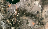
and a continuation map showing all the N-S craters and the Long Valley Caldera which exploded the tufa shown in Post #17 above, into the Owen Vally and almost to Bishop. 65 miles, Mono Lake to Bishop.

map and guide. 1. Bodie is an intact mining town, buildings and cemetery notable. 2. Beautiful expanse of view. 3. That's actually the South Crater, Panum, not North Crater here in error, trail into black obsidian core of volcano. 4 South Beach- off Hwy 120- can go into the water here, float w/out moving, very salty, must wash off afterwards. 5. Road off Hwy 120 N. into Audubon Sanctuary area.
Tufa formations from former high level of lake. Recent geologic, volcanic islands Negit and Paoha in the lake.
Lots of German tourists seem to like and seek out mineral waters. They converge on the small town of Lee Vining annually, and like to float in the water around South Beach, by (3) on the map by South (not North) Crater off Hwy 120. It is said that in restaurants in town often all you will hear is German spoken.
South (Panum) Crater, Paoha and Negit islands. The type of obsidian abundant in crater, some white & black.
Top-bottom: Mono Lake- taken from Lee Vining Peak, and islands.
Mono Craters in distance on N-S line from Panum Crater, and Williams Butte, close-up, taken from Upper Horse Meadow, just outside of town Lee Vining. Not Hwy 120, looking east.
L-R: Mts. Gibbs and Dana, taken from Upper Horse Meadow, (5) on the map above, looking west.
Another photo of Mono Craters (old volcanos) https://en.wikipedia.org/wiki/Mono–Inyo_Craters
and the Inyo Craters. https://www.bing.com/search?q=Inyo+...efig=6913ebdc0a064b79a821ffce1ac85dd3&pc=DCTS
and a continuation map showing all the N-S craters and the Long Valley Caldera which exploded the tufa shown in Post #17 above, into the Owen Vally and almost to Bishop. 65 miles, Mono Lake to Bishop.
Attachments
difalcojr
- 459
- 352
black (smoky) quartz crystal, hexagonal, translucent, from Sierra Nevada Mtns near Mono Lake, CA, both sides shown. About 16.5cm long x 9cm wide x 5cm thick, and 1 kg in weight. Worn-down rock on its top (left side) shows it was used as a pounding tool. Fits well in one's hand, possible alternative use was as a weapon.
difalcojr
- 459
- 352
And every photo in the adjacent geology thread "The secrets-of-prof-verschures-rosetta-stones."
Though I would like a summary of the secrets, if possible, at this time. I need a graduate class in geology, otherwise. All those photos are spectacular.
Though I would like a summary of the secrets, if possible, at this time. I need a graduate class in geology, otherwise. All those photos are spectacular.
Similar threads
- BillTre
- · Replies 8 ·
- Earth Sciences
- Replies
- 8
- techmologist
- · Replies 12 ·
- Earth Sciences
- Replies
- 12
- tree-lights
- · Replies 2 ·
- Earth Sciences
- Replies
- 2
- Tokage
- · Replies 2 ·
- Earth Sciences
- Replies
- 2
- hiddenvariabl
- · Replies 6 ·
- STEM Academic Advising
- Replies
- 6
Writing: Input Wanted
Geology of Great Lakes Earth, an alternate world dominated by lakes
- JohnWDailey
- · Replies 6 ·
- Sci-Fi Writing and World Building
- Replies
- 6
- Alessandra88
- · Replies 24 ·
- STEM Academic Advising
- Replies
- 24
- I like Serena
- · Replies 0 ·
- MATLAB, Maple, Mathematica, LaTeX
- Replies
- 0
- vanmaiden
- · Replies 3 ·
- Computing and Technology
- Replies
- 3
- gonzo
- · Replies 30 ·
- Special and General Relativity
- Replies
- 30