Formation and evolution of the Great Lakes in US/Canada border

In summary: Henderson Lake was named for General Zebulon Pike, who explored the area in the early 1800s."In summary, The History Channel program on the formation of the Great Lakes was interesting and fascinating. The huge salt deposits under the Lakes Michigan, Huron and Erie and fossilized sea sponges provide evidence of a salt water sea in the past. Limestone formed from successive corral reefs, and when the sea water evaporated, the top layer of limestone was transformed into a hard rock, dolestone, a (Ca, Mg)(CO3)2, also known as dolomite. The three lakes formed after the melting of an ice sheet, but at least ten ice sheets formed and melted
  • #1
Astronuc
Staff Emeritus
Science Advisor
2023 Award
21,868
6,259
I was watching a program on the formation of the Great Lakes, and it is quite interesting and fascinating.

The huge salt deposits under the Lakes Michigan, Huron and Erie and fossilized sea sponges provide evidence of a salt water sea in the past. Limestone formed from successive corral reefs, and when the sea water evaporated, the top layer of limestone was transformed into a hard rock, dolestone, a (Ca, Mg)(CO3)2, also known as dolomite. The three lakes formed after the melting of an ice sheet, but at least ten ice sheets formed and melted during different periods of time. The last ice sheet melted about 14,000 years ago.

https://en.wikipedia.org/wiki/Dolomite_(rock)

Lake Superior and Ontario formed differently from the other three. Superior and Ontario were formed as part of rifts. Each lake was formed by a different, separate rift event, with Ontario's occurring much later than Superior's rift. The St. Lawrence river (Seaway) was formed by the same rift forming Lake Ontario.
The cliffs on the shores of Lake Superior—and the lake itself—are part of such a fossilized rift. Called the Midcontinent Rift (MCR), this 3000-kilometer-long feature, made of 1.1-billion-year-old igneous and sedimentary rocks, extends underground across the central United States. It stands as one of the best examples of a failed rift
https://eos.org/features/new-insights-into-north-americas-midcontinent-rift
https://eos.org/articles/long-live-the-laurentian-great-lakes
https://lakeheadca.com/events-education/geology/mid-continent-rift
https://www.lakesuperior.com/the-lake/402rockin-the-rift-the-billion-year-old-split-that-made-us/
https://www.usgs.gov/news/science-snippet/understanding-mineral-resources-midcontinent-rift
https://en.wikipedia.org/wiki/Midcontinent_Rift_System

https://en.wikipedia.org/wiki/Glacial_Lake_Iroquois
https://en.wikipedia.org/wiki/Lake_Algonquin

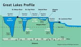
Formation of the Great Lakes in US and Canada


With the lack of ice sheet, which weighed down the land, the area around the Great Lakes is rising, so eventually, it is expected the lakes to rise and in some cases, the water will stop flowing to the lake region. There would still be precipitation. At the same time, the erosion of Niagara Falls will reach lake Erie at some point, and Lake Erie and the others will drain very quickly.

The History Channel mentioned that the Great Lakes levels had fallen, but the following article mentions that they fall and rise about a mean level. However, that it a limited time span.
https://www.popsci.com/story/environment/great-lakes-water-rise/
 
Last edited:
  • Like
Likes sysprog, 256bits, anorlunda and 3 others
Earth sciences news on Phys.org
  • #2
This article about Ridge Ave/Road in Chicago and Northward into Green Bay Road includes discussion of the fact that the conspicuous ridge is there because long ago a giant glacier pushed the land back and then receded ##-## https://en.wikipedia.org/wiki/Lake_Chicago.
 
  • Like
Likes 256bits, Lnewqban and Astronuc
  • #3
Astronuc said:
At the same time, the erosion of Niagara Falls will reach lake Erie at some point, and Lake Erie and the others will drain very quickly.
A depth chart of the lakes.
Except for Lake Erie, the base depth of the other lakes extends below sea level.
One can kinda see the rift effect in the formation of the lakes by their v-shape, but I woudn't have guessed until @Astranut mentioned it.

1644156068684.png

1644156331292.png


Midcontinent rift ( so what is that thing doing there... trying to split us up a billion years ago )
1644157672303.png

https://en.wikipedia.org/wiki/Midcontinent_Rift_System
 

Attachments

  • 1644155884791.png
    1644155884791.png
    34.1 KB · Views: 110
  • Like
  • Informative
Likes Klystron, BillTre, Bystander and 2 others
  • #4
TV producers are always on the lookout for subjects that would be popular with viewers, but affordable to produce. IMO, historical geology might be popular to viewers. Personally, I would most enjoy:
  • The formation of the Lake Champlain valley/Green Mountains/Adirondack Mountains.
  • Erosion of the Appalachian Mountains transporting sand to the SW of North America which became sandstone.
  • The formation of Verrazano Narrows separating Staten Island from Long Island caused by emptying of a glacial lake.
  • The opening of the Mediterranean to the Atlantic at Gilbralter.
  • The formation of the Columbia River caused by emptying of a glacial lake.
  • The Bahamas and Florida when sea levels were 400 feet (120m) lower than today.
  • The formation of Hudson and Baltimore Canyons in the continental shelf of North America when sea levels were lower. Both are said to rival Grand Canyon in size.
  • Separation of South America from Africa.
  • 9 km high glaciers, including formation and effects.
  • Drumlins
  • The Waterpocket Fold in Utah.
  • This feature in the South Dakota badlands and the informational sign beside it.
    1644158899576.png
    1644158936564.png
Many viewers may have their own personal wish list.
 
  • Like
Likes Klystron, BillTre, Astronuc and 1 other person
  • #5
Formation of Lake Champlain, the Champlain Valley and Hudson River and Valley seem to be related.

https://www.whoi.edu/oceanus/feature/the-great-flood-of-new-york/
https://atlas.lcbp.org/nature-environment/geology/

https://www.lakechamplaincommittee.org/learn/natural-history-lake-champlain

Adirondacks are apparently a unique mountain system.
https://apa.ny.gov/About_Park/geology.htm

Interestingly, "Lake Tear of the Clouds is a small tarn located in the town of Keene, in Essex County, New York, United States, on the southwest slope of Mount Marcy, the state's highest point, in the Adirondack Mountains. It is the highest pond in the state. It is often cited as the highest source of the Hudson River." However, "the Hudson River as named actually begins several miles southwest at the outlet of Henderson Lake in Newcomb, New York."
https://en.wikipedia.org/wiki/Lake_Tear_of_the_Clouds
 
  • Like
Likes anorlunda and Lnewqban
  • #6
Thanks @Astronuc , that natural history lake agrees with research I did before. It says:
The precursor to Lake Champlain formed about 200 million years ago. At that time the stretching of continents caused a massive piece of bedrock to fall down between two parallel faults forming a deep canyon known as a graben valley.
Similar to this limestone formation, but a massive piece of bedrock roughly 60x120 miles (100x200 km).
1644173697642.png


Also interesting is this from Wikipedia that portrays the Champlain and Hudson Valleys as part of the Great Appalachian Valley.
1644173525820.png
 
  • Like
Likes Lnewqban and Astronuc
  • #7
  • Like
Likes jtbell and Lnewqban
  • #8
That Morton Salt mine in Fairport Harbor OH was the home of the Irvine-Michigan-Brookhaven detector in the 1980s. It was built to look for proton decay, then had a second career as a neutrino detector, most notably from Supernova SN 1987A. I knew some of the grad students and professors at Michigan who worked on it.
 
  • Like
Likes Astronuc
  • #9
jtbell said:
That Morton Salt mine in Fairport Harbor OH was the home of the Irvine-Michigan-Brookhaven detector in the 1980s. It was built to look for proton decay, then had a second career as a neutrino detector, most notably from Supernova SN 1987A. I knew some of the grad students and professors at Michigan who worked on it.
https://icecube.wisc.edu/neutrino-h...eports-measurement-of-non-zero-neutrino-mass/With respect to 'rifts' in the Earth's crust - https://phys.org/news/2022-02-tectonic-plates-formation-rifts.html
 

1. What is the geological process that led to the formation of the Great Lakes?

The Great Lakes were formed during the last Ice Age, approximately 10,000 years ago. As glaciers advanced and retreated, they carved out deep basins in the land, which eventually filled with water from melting ice and precipitation.

2. How did the Great Lakes evolve over time?

The Great Lakes have undergone significant changes since their formation. Glacial activity, erosion, and shifts in climate have all played a role in shaping the lakes and their surrounding landscapes. In addition, human activities such as logging, agriculture, and industrialization have also impacted the Great Lakes region.

3. What factors contribute to the unique ecosystems found in the Great Lakes?

The Great Lakes are home to a diverse range of plant and animal species, including many that are endemic to the region. This is due to a combination of factors, such as the lakes' large size, varied topography, and diverse habitats, as well as the influence of both cold and warm water currents.

4. How have human activities affected the Great Lakes?

Human activities have had both positive and negative impacts on the Great Lakes. On one hand, the lakes have provided valuable resources for transportation, industry, and recreation. However, pollution, invasive species, and overfishing have also had detrimental effects on the lakes' ecosystems and water quality.

5. What measures are being taken to protect and preserve the Great Lakes?

In recent years, there has been a growing effort to protect and preserve the Great Lakes. This includes initiatives such as reducing pollution, restoring habitats, and promoting sustainable practices. Various government agencies, non-profit organizations, and community groups are also working together to address the challenges facing the Great Lakes and ensure their long-term health and sustainability.

Similar threads

Replies
6
Views
971
Replies
2
Views
1K
Writing: Input Wanted Great Lakes Earth Map
  • Sci-Fi Writing and World Building
Replies
6
Views
2K
Writing: Read Only Great Lakes Earth
  • Sci-Fi Writing and World Building
Replies
1
Views
3K
  • Sci-Fi Writing and World Building
Replies
2
Views
2K
  • Earth Sciences
3
Replies
101
Views
30K
  • Earth Sciences
Replies
10
Views
8K
Replies
8
Views
5K
  • Earth Sciences
Replies
4
Views
8K
Back
Top