How Far Can Smoke From Canadian Wildfires Travel?
- Thread starter jtbell
- Start date
-
- Tags
- Smoke
Join the discussion
Registration is free. Ask a follow-up in this thread, or start your own.
20 replies · 4K views
Earth sciences news on Phys.org
Discussion

Staff Emeritus
Science Advisor
Education Advisor
Gold Member
Dearly Missed
- 35,014
- 21,725
Why should California get all the fun?
- 20,002
- 11,121
Time to get the covid masks back out!
Mentor
- 23,902
- 11,357
And the air purifier. My office was terrible today so I'll work from home tomorrow.Greg Bernhardt said:Time to get the covid masks back out!
Science Advisor
Gold Member
- 2,408
- 5,259
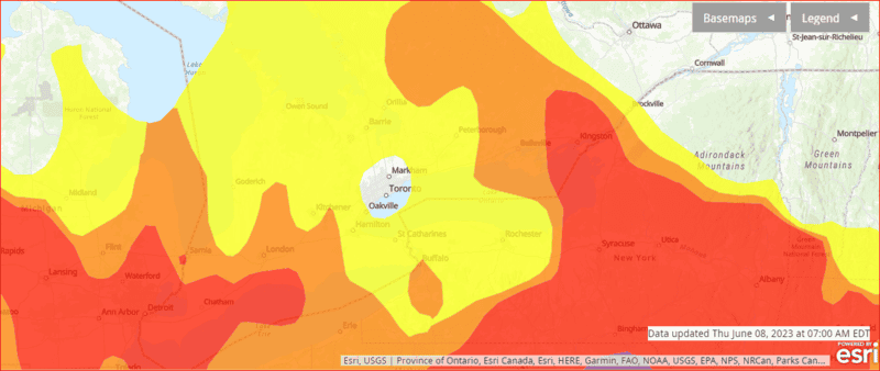
BTW, there is a government web site that tracks air quality:
https://www.airnow.gov/
This is their interactive map:
https://gispub.epa.gov/airnow/?showgreencontours=false
https://www.airnow.gov/
This is their interactive map:
https://gispub.epa.gov/airnow/?showgreencontours=false
256bits
Gold Member
- 4,284
- 2,297
For a positive spin, hang out a chunk of meat and you can get the smoked version in return.
Make your own bacon. :)
Make your own bacon. :)
Staff Emeritus
Science Advisor
Gold Member
2025 Award
- 22,714
- 7,805
Definitely. Here is looks like fog, but it's smoke. Sky was either grey or slightly brown, and the sun was an orange dot above. I wear an N95 outside.Greg Bernhardt said:Time to get the covid masks back out!
It's not as bad as NY City, but the air quality has ranged from unhealthy to very unhealthy.
LaGuardia (LGA) airport suspended flights because of poor visibility.
I've experienced this in the Pacific NW and now the east coast, which has the worst air quality since the 1960s. Apparently about 150 wildfires in Quebec alone, and something like 600 wildfires in Canada.Edit/update:
I heard a statement from the NY governor that AQI in New York (maybe city) hit about 400 yesterday, up from about 50, or an increase of about 800%.The Air Quality Index spiked to "hazardous" levels in Philadelphia, where everyone was urged to stay inside.
https://www.yahoo.com/news/canadian...s-airplanes-in-us-live-updates-152013981.html
I heard a meteorologist talking about a low pressure system west of NY (I'm guessing the Ohio Valley), such that smoke will move west from the coast. So perhaps Ohio, and perhaps Kentucky, will be getting more smoke.
https://www.nbcnews.com/news/us-new...ality-canada-wildfires-live-updates-rcna88092Hochul said that normally the Air Quality Index is around 50 and that Brooklyn measured 413 and Queens 407 on Wednesday.
Last edited:
TonyStewart
- 306
- 132
I have no idea why Toronto is clean at the moment. But the Lake Effects and gentle warm water flowing out of Pickering Nuclear Reactors just inside this bubble, have always lead me to believe why we get far less snow than Buffalo and now cleaner air.
- 3,777
- 2,002
There is also an app you can download onto your phone which can be set to your location. I got it a couple of years ago when we had the fire here near Portland, and I want to keep tabs on the air quality.Borg said:BTW, there is a government web site that tracks air quality:
https://www.airnow.gov/
This is their interactive map:
https://gispub.epa.gov/airnow/?showgreencontours=false
- 3,777
- 2,002
Just be sure that they are N-95s, as those are the only ones rated to keep out the smaller smoke particles. Right after we had the bad fires and air quality issues here, we got some to keep on hand for future use, as smoke related problems due to wildfires has become more of an issue in the last few years for us.Greg Bernhardt said:Time to get the covid masks back out!
Science Advisor
Gold Member
- 2,856
- 12,709
Like some others here, I live on the west coast (Oregon) and have experienced a lot of smoke from forest fires in previous years.
Here are some map sites I found that can be zoomed out for much wider views:
Pac. NW smoke: shows fire, air quality sensors, and through the little white box in the upper right smoke plumes (zooms out to show N. America): https://tools.airfire.org/airtools/v1/pnw-smoke.html?lat=44.0&lng=-118.2&zoom=6
Here is a similar one: https://www.oregonsmoke.org/
Here is another that can also show traffic patterns (good to know when there are fires along highways):
https://geo.maps.arcgis.com/apps/PublicInformation/index.html?appid=f8a0d8814a67445a9e6bf3485f4fd24f
Different layer displays are in the upper left box.
Here are some map sites I found that can be zoomed out for much wider views:
Pac. NW smoke: shows fire, air quality sensors, and through the little white box in the upper right smoke plumes (zooms out to show N. America): https://tools.airfire.org/airtools/v1/pnw-smoke.html?lat=44.0&lng=-118.2&zoom=6
Here is a similar one: https://www.oregonsmoke.org/
Here is another that can also show traffic patterns (good to know when there are fires along highways):
https://geo.maps.arcgis.com/apps/PublicInformation/index.html?appid=f8a0d8814a67445a9e6bf3485f4fd24f
Different layer displays are in the upper left box.
Staff Emeritus
Science Advisor
Gold Member
2025 Award
- 22,714
- 7,805
Yesterday, I think our AQI was in the range of 240-300. This morning when I checked we were at 144 and then picked up to about 166 this afternoon, but then is dropped this evening to a more normal level, currently ~60.
We were not as bad as New York City, Philadelphia, and other places.
We were not as bad as New York City, Philadelphia, and other places.
Mentor
- 38,152
- 10,760
I've seen several articles in the newspapers about smoke back east due to fires in Canada, but not much about fires here in the Northwest, where I live. I went for a motorcycle ride this past Thursday, over to Leavenworth and back, and the air was quite hazy in the Skykomish Valley. The only fire I've seen reported is a small one near Yakima, WA.
It rained most of the day yesterday here, so that should clean the air up substantially. We hadn't had any rain since about three weeks ago, so it's been a pretty dry May/June, unusual for NW Washington.
It rained most of the day yesterday here, so that should clean the air up substantially. We hadn't had any rain since about three weeks ago, so it's been a pretty dry May/June, unusual for NW Washington.
Staff Emeritus
Science Advisor
Gold Member
2025 Award
- 22,714
- 7,805
Yesterday, we had low AQI ~12-14, which is perhaps typical. It went up to about 24. This morning I did not check the number, but currently it's about 58 locally and 83 regionally, which means some places have it worse than us. It's actually quite variable.
Last edited:
Science Advisor
Gold Member
- 2,856
- 12,709
Where would this be?Astronuc said:Yesterday, we have low AQI ~12-14, which is perhaps typical. It went up to about 24. This morning I did not check the number, but currently it's about 58 locally and 83 regionally, which means some places have it worse than us. It's actually quite variable.
Staff Emeritus
Science Advisor
Gold Member
2025 Award
- 22,714
- 7,805
NE US. This morning AQI is up to 74-75 and apparently increasing, and regionally, about 68-69, and perhaps increasing. New York City is at 87. Buffalo, NY and Hartford, CT have AQIs ~ 94-95, and Boston is at 105. Philadelphia has AQI of 91. Washington, DC is at 75.BillTre said:Where would this be?
Houston, TX and San Diego, CA hae AQIs of 24 and 25, respectively. Seattle, WA is at 51. Richland, WA on the eastern side of the Cascade mountains and in the Columbia River Valley has AQI of 33.
The weather app in my phone shows AQI for different locations.
Staff Emeritus
Science Advisor
Gold Member
2025 Award
- 22,714
- 7,805
Canadian wildfire smoke detected in Norway.
https://www.yahoo.com/lifestyle/canadian-wildfire-smoke-detected-thousands-212242196.html
https://www.yahoo.com/lifestyle/canadian-wildfire-smoke-detected-thousands-212242196.html
The smoke from wildfires in eastern Canada has reached all the way across the Atlantic Ocean to Norway, more than 3,000 miles (4,800 kilometers) away.
Similar threads
- biggspc
- · Replies 5 ·
- Mechanics
- Replies
- 5