Hurricane Beryl, Early Season and Rapid Intensification

  • Thread starter Thread starter Astronuc
  • Start date Start date
Click For Summary

Discussion Overview

The discussion centers on Hurricane Beryl, focusing on its rapid intensification, projected path, and potential impacts as it approaches the Caribbean and the Gulf of Mexico. Participants explore various aspects of the hurricane's development, including its record early season formation and the implications for affected regions.

Discussion Character

  • Exploratory
  • Technical explanation
  • Debate/contested
  • Experimental/applied

Main Points Raised

  • Some participants note that Hurricane Beryl has intensified into a Category 4 storm, marking it as the earliest Category 4 hurricane on record in the Atlantic Ocean.
  • Others discuss the unusual timing of the hurricane's formation, as the average date for the first hurricane is typically August 11.
  • There are varying projections regarding Beryl's path, with some suggesting it may shift northward towards Jamaica, while others speculate on its potential to strengthen again after encountering land.
  • One participant mentions the Atlantic Ocean temperatures being unusually high, comparable to those in September, raising concerns about the storm's intensity.
  • As of July 3, Beryl was reported to have weakened slightly but could regain strength over warm waters, with forecasts indicating a potential landfall in Texas as a Category 1 hurricane.
  • Another participant highlights the expected heavy rainfall and flooding along the Texas coast, particularly in areas like Freeport, Galveston, and Houston.

Areas of Agreement / Disagreement

Participants express multiple competing views regarding the hurricane's trajectory and intensity, with no consensus on its future developments or impacts. The discussion remains unresolved with ongoing updates and predictions.

Contextual Notes

Limitations include the uncertainty surrounding the hurricane's path and intensity, as well as the reliance on evolving meteorological data and models.

Astronuc
Staff Emeritus
Science Advisor
Gold Member
2025 Award
Messages
22,514
Reaction score
7,454
Hurricane Beryl strengthens into a Category 4 storm as it nears the southeast Caribbean
https://apnews.com/article/hurricane-beryl-caribbean-islands-aaae273e307658866fdd27f9f2c76592

Hurricane Beryl intensifies into an ‘extremely dangerous’ Category 4 storm as it approaches the Caribbean
https://www.cnn.com/2024/06/30/weather/hurricane-beryl-barbados-caribbean-sunday/index.html

Beryl, the first hurricane of the 2024 Atlantic season, intensified to an extremely dangerous Category 4 hurricane with maximum sustained winds of 130 mph Sunday morning, as it made its way toward the Windward Islands.

Beryl is now the earliest Category 4 hurricane on record in the Atlantic Ocean and the only Category 4 storm ever recorded in the month of June.

Tropical storm-force winds are expected to reach the Windward Islands late Sunday or early Monday.

The early timing of the season’s first hurricane is unusual, given the average date for the first hurricane is August 11.

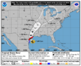
As of 5 p.m. ET, Beryl was about 250 miles east southeast of Barbados, heading west, and on track to hit Yucatan Peninsula by Friday (5 days) and possibly into the Bahia De Campeche (Bay of Campeche) unless it veers NW or N.

https://www.cbsnews.com/news/hurricane-beryl-forecast-powerful-storm-caribbean-islands/

https://www.nhc.noaa.gov/graphics_at2.shtml?cone
https://www.nhc.noaa.gov/storm_grap...024_5day_cone_no_line_and_wind+png/205226.png
 
  • Wow
Likes   Reactions: pinball1970
Earth sciences news on Phys.org
It's projected track has shifted a bit north with the center path just south of Jamaica as a major hurricane.
115445_5day_cone_no_line_and_wind.png
 
  • Informative
Likes   Reactions: pinball1970
The Rio Grande and Rio Conchos watersheds need the precipitation, but not all at once.

It will be interesting to see if the storm strengthens back to hurricane (Cat 1 or 2) on Sunday, and/or it veers more westward, stays on track to the NW or veers right (N) along the coast of Mexico and Texas.

One possible scenario -
https://www.yahoo.com/news/mapped-hurricane-beryl-barrels-towards-092553042.html
 
Last edited:
Apparently Atlantic ocean temperatures already rival those for Septembers at peak of storm season....
Batten the hatches ??
 

July 2 - Hurricane Beryl, now a powerful Category 5 storm, barrels toward Jamaica​

https://www.npr.org/2024/07/02/nx-s1-5026426/hurricane-beryl-jamaica-forecast

https://news.yahoo.com/news/hurricane-beryl-explodes-category-5-071212134.html

This morning (July 3), Beryl was described at Cat 4. It weakens slightly as it encounters land/islands, but could strengthen over warm open waters.

https://www.nhc.noaa.gov/archive/2024/BERYL.shtml? archived information.

Some predictions over the next 5 days.
https://www.nhc.noaa.gov/archive/2024/al02/al022024.discus.021.shtml?

FORECAST POSITIONS AND MAX WINDS (Compare in 5 days).

INIT 03/2100Z 17.5N 77.6W 120 KT 140 MPH
12H 04/0600Z 18.1N 80.3W 110 KT 125 MPH
24H 04/1800Z 18.7N 83.7W 95 KT 110 MPH
36H 05/0600Z 19.2N 86.7W 85 KT 100 MPH
48H 05/1800Z 19.9N 89.5W 55 KT 65 MPH...INLAND
60H 06/0600Z 20.9N 91.8W 50 KT 60 MPH...OVER WATER
72H 06/1800Z 21.9N 93.9W 55 KT 65 MPH
96H 07/1800Z 24.0N 96.9W 65 KT 75 MPH
120H 08/1800Z 26.0N 98.5W 45 KT 50 MPH...INLAND
 
Last edited:
  • Like
  • Informative
Likes   Reactions: pinball1970 and Nik_2213
Friday, July 5, 2024
https://www.yahoo.com/news/hurricane-beryl-tracker-maps-show-133558037.html

Hurricane Beryl Heading into the Southern Gulf
https://www.yahoo.com/news/beryl-becomes-hurricane-forecast-reach-205517085.html

Edit/update
https://www.yahoo.com/news/hurricane-beryl-weakens-category-2-103127399.html
Beryl will probably weaken to a Cat 1 or tropical storm before regaining strength over the Gulf of Mexico. It looks like it might move north of Brownsville, and Corpus Christi will get the northwest quadrant with heavy winds and storm surge.
 
Last edited:
  • Like
  • Informative
Likes   Reactions: pinball1970 and OmCheeto
Beryl seems to be turning more northward along the Texas coast. It looks like the eye will cross the coast between Port O'Connor and Matagorda, then move northward. Freeport, Galveston and Houston will get lots of rain and flooding.

https://www.nhc.noaa.gov/refresh/graphics_at2+shtml/091527.shtml?cone#contents


Edit/update:
Tropical Storm Beryl is expected to make landfall near Matagorda as a Category 1 hurricane early Monday morning, according to the National Weather Service.
https://www.yahoo.com/news/hurricane-beryl-likely-hit-texas-214707192.html
 

Attachments

  • Hurricane,TS_Beryl_091527_5day_cone_no_line_and_wind.png
    Hurricane,TS_Beryl_091527_5day_cone_no_line_and_wind.png
    107.8 KB · Views: 86
Last edited:

Similar threads

  • · Replies 3 ·
Replies
3
Views
3K
  • · Replies 7 ·
Replies
7
Views
2K
  • · Replies 10 ·
Replies
10
Views
4K