Andre
- 4,296
- 73
Amazing GRACE
Nereid
Amazing GRACE and GOZE and breath taking results:
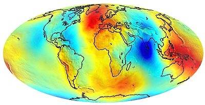
Notice that the deep red areas are more or less -very roughly- antipode. That reminds me of another World map in relation to sea levels:
http://home.wanadoo.nl/bijkerk/palaeogeography.GIF
With a little imagination you could draw an oblique geographic world from that, the poles being in the centre of the blue spots, the equator following the big orange wave. Aint it curious?
This is the origine of that second pic: http://www.sciencemag.org/cgi/content/full/295/5564/2438
Nereid
Amazing GRACE
and GOZE and breath taking results:Notice that the deep red areas are more or less -very roughly- antipode. That reminds me of another World map in relation to sea levels:
http://home.wanadoo.nl/bijkerk/palaeogeography.GIF
With a little imagination you could draw an oblique geographic world from that, the poles being in the centre of the blue spots, the equator following the big orange wave. Aint it curious?
This is the origine of that second pic: http://www.sciencemag.org/cgi/content/full/295/5564/2438
Last edited by a moderator:
