Hunga Tonga-Hunga Haʻapai volcano eruption, Tonga, Tsunami(s)

  • Thread starter Thread starter Astronuc
  • Start date Start date
  • Tags Tags
    Volcano
Click For Summary
A massive underwater volcanic eruption from Hunga Tonga-Hunga Haʻapai triggered tsunami waves that struck Tonga, particularly affecting the capital, Nuku'alofa, located 65 km away. Eyewitness accounts and social media footage revealed significant flooding in low-lying areas, with ash falling over the city. The eruption was one of the largest in the region in 30 years, generating shock waves heard across the South Pacific, reaching as far as New Zealand and California. Initial reports indicated no immediate casualties, but the New Zealand government is preparing to assist Tonga, focusing on providing clean water due to contamination from ash. The event has raised concerns about potential future eruptions and their environmental impacts.
Astronuc
Staff Emeritus
Science Advisor
Gold Member
Messages
22,420
Reaction score
7,298
TL;DR
Hunga Tonga-Hunga Haʻapai volcano eruption, tsunami hits Tonga

Tsunami hits Tonga after giant volcano eruption (20.536°S, 175.382°W)​

https://www.bbc.com/news/world-asia-60007119

Tsunami waves caused by a giant underwater volcanic eruption have hit the Pacific country of Tonga.
Social media footage showed water washing through a church and several homes, and witnesses said ash was falling over the capital, Nuku'alofa.

The eruption of the Hunga Tonga-Hunga Haʻapai volcano was heard across the South Pacific, reportedly as far as New Zealand and Australia.
Tonga's capital lies just 65km north of the volcano, on the country's main island of Tongatapu.
Not much in the way of an earthquake. I can only find a couple of Mag 5.0 earthquakes in the past week.

11-Jan, https://earthquake.usgs.gov/earthquakes/eventpage/us7000gay1/executive
10-Jan, https://earthquake.usgs.gov/earthquakes/eventpage/us7000gank/executive

https://volcano.si.edu/volcano.cfm?vn=243040
https://en.wikipedia.org/wiki/Hunga_Tonga

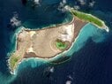
The volcano itself is a submarine volcano that breached sea level in 2009 due to a volcanic eruption and lies underwater between the two islands (Hunga Tonga and Hunga Ha'apai), which are the remnants of the western and northern rim of the volcano's caldera.

The volcano sits ~65 km north of Tonga's capital, Nuku'alofa.

https://www.nesdis.noaa.gov/news/hunga-tonga-hunga-haapai-erupts-again

Prof Shane Cronin, a volcanologist at the University of Auckland, said the eruption was one of the biggest in Tonga in the past 30 years.
I'm trying to learn more about volcano and it's situation with respect to the rest of Tonga.https://en.wikipedia.org/wiki/Fonuafo'ou
https://en.wikipedia.org/wiki/Tongatapu
Nukuʻalofa is the capital of Tonga. It is located on the north coast of the island of Tongatapu, in the country's southernmost island group.
https://en.wikipedia.org/wiki/Nukuʻalofa

I'm particularly interested in the jog in the Australia and Pacific tectonic plates where Tonga sits.

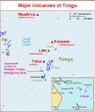
Edit/update - I corrected the location of the volcano with repsect to Nukuʻalofa on the island of Tongatapu, and I attached a map image of Tonga and its volcanoes (source: Smithsonian Institution).
 

Attachments

  • 4001hun12f.jpg
    4001hun12f.jpg
    63.3 KB · Views: 240
Last edited:
  • Like
  • Wow
  • Informative
Likes Santiago24, Klystron, BillTre and 3 others
Earth sciences news on Phys.org

M 5.8 Volcanic Eruption - 68 km NNW of Nuku‘alofa, Tonga​

  • 2022-01-15 04:14:45 (UTC)
  • 20.546°S 175.390°W (close to 20.536°S, 175.382°W in the OP)
  • 0.0 km depth
https://earthquake.usgs.gov/earthquakes/eventpage/us7000gc8r/executive

This may be the event, but I'm still looking into it.

Oddly enough, one finds sesimological graphs by USGS on Facebook, but not on the USGS site.
https:// www . facebook . com/photo/ ?fbid=301353842039091&set=a.236095165231626

I broke the link, but one can cut and paste and remove the spaces in the URL
 
 
  • Like
Likes davenn and Astronuc
https://www.stuff.co.nz/national/12...stayoffbeach-warning-following-tongan-tsunami

Tsunami waves swamped low-lying areas of the Pacific Island nation on Saturday following an underwater volcanic eruption.

The Pacific Tsunami Warning Center in Hawaii, US, confirmed the eruption generated a tsunami late on Saturday night. It followed an earlier eruption, on Friday, that sent ash, steam and gas 20 kilometres into the air.
Another news article: https://www.stuff.co.nz/world/south...es-in-tonga-after-underwater-volcano-eruption


Video showing Earth with Tonga in lower right quadrant of video. One can see the shock wave expanding from Tonga.

For those who visit Facebook, Aurora Borealis Observatory has a nice video from the Himawari-8 geostationary satellite
https://www . facebook . com/ auroraborealisobservatory/videos/300042298612272
 
  • Wow
  • Like
Likes davenn, Jarvis323 and BillTre


  • Like
Likes davenn and BillTre
https://www.stuff.co.nz/national/30...-can-help-in-tonga-after-eruption-and-tsunami
Comments made by our Prime Minister:
1. "The Government has been urgently trying to find out what is happening in Tonga. As yet there are no official reports of injuries or deaths. NZ High Commission staff are safe, Ardern said."

2. "Communictions remain very limited, Ardern said.
The main undersea communications cable has been impacted, likely due to a loss of power."

3. "This morning the top of the ash cloud was estimated to be 63,000 feet, higher than a NZ aircraft was able to fly, Ardern said.
Ardern said she would be speaking to Australian PM Scott Morrison today and were ready to help.

Along with the aircraft flight, NZ was considering the deployment of a naval ship should it be needed, Ardern said. For now the Government was waiting to hear from Tongan authorities about what was needed."

4. "A clear indication had come from Tonga of a need for water, after the ash cloud caused contamination. So the NZDF was focused on supplying that, Ardern said."
 
  • #10
Jarvis323 said:
a violent eruption of an underwater volcano on January 15 has spread shock waves, quite literally, around half the world.
Some people from California mentioned they heard a roar and thought it was jet aircraft. It was apparently the volcano in Tonga, which is 8,557 km (5320 miles) from San Francisco, CA.

That's a great article on the volcano/caldera.
The two earlier eruptions on December 20 2021 and January 13 2022 were of moderate size.

It seems folks are waiting for a BIG one. I guess the one that just happened was only big.
 
  • #12
Astronuc said:
Some people from California mentioned they heard a roar and thought it was jet aircraft. It was apparently the volcano in Tonga, which is 8,557 km (5320 miles) from San Francisco, CA.
Am trying to figure out what time the shock would have washed across the Eastern Seaboard. Very littel data.
 
  • #13
Also: this video (TikToc) is certainly of the eruption but I can't verify how far way. It highly doubt it is from Fiji.
 
  • #14
  • Like
Likes russ_watters
  • #15
From the times @Borek mentioned that he observed pressure changes in Poland (in a GD thread), the shock wave seems to have propagated at around 1091km/h, a typical speed of sound at 30,000ft (but temperature-dependent). So you should be able to estimate when it would reach any point on the globe given the distance.
 
  • #16
Jonathan Scott said:
From the times @Borek mentioned that he observed pressure changes in Poland (in a GD thread), the shock wave seems to have propagated at around 1091km/h, a typical speed of sound at 30,000ft (but temperature-dependent). So you should be able to estimate when it would reach any point on the globe given the distance.
I did some comparison with the data from other places and calculated speed wasn't entirely consistent, I suppose our clocks could be a bit off as well as detection of the shockwave maximum. But in general yes, no doubt it is in a speed of sound ballpark.
 
  • #17
An EU weather website is quoting 1100km/h which seems very similar:

The exact speed will depend on the temperature of the atmosphere along the propagation path.
 
  • #18
Jonathan Scott said:
From the times @Borek mentioned that he observed pressure changes in Poland (in a GD thread), the shock wave seems to have propagated at around 1091km/h, a typical speed of sound at 30,000ft (but temperature-dependent). So you should be able to estimate when it would reach any point on the globe given the distance.
I believe folks in the US who heard it were along the west coast (in California), so what they heard would have propagated across the ocean at sea level, with some dispersion, and there is some reflection from tropopause.

I also wonder if the BIG eruption could be like that of Krakatoa (Krakatau) in 1883.
https://en.wikipedia.org/wiki/1883_eruption_of_Krakatoa

Incidentally, https://en.wikipedia.org/wiki/1883_eruption_of_Krakatoa#Pressure_wave
 
  • #19
I've been following Shane Cronin's and Simon Carn's twitter accounts waiting for updates on the scientific analysis.

https://twitter.com/scronin70
https://twitter.com/simoncarn

It seems a little uncertain still how large the eruption was and if it is just the start of something much bigger or not. There has been some estimations of how much SO2was released, which determines I guess what kind of climate impact it could have, and it looks like, as of now, Simon is saying that there wasn't enough released so far to have a significant climate impact (and much less than the Pinatubo eruption). There is a good article to give some context about this topic.

https://eos.org/science-updates/anticipating-climate-impacts-of-major-volcanic-eruptions
 
  • Like
Likes davenn and Astronuc
  • #20
Jonathan Scott said:
An EU weather website is quoting 1100km/h which seems very similar:

The exact speed will depend on the temperature of the atmosphere along the propagation path.


Sadly the image is nonsensical - orthodrome linking Tonga and Europe goes through northern Siberia, not through Middle America.
 
  • #21
Borek said:
Sadly the image is nonsensical - orthodrome linking Tonga and Europe goes through northern Siberia, not through Middle America.
OK, so the line has only 2 accurate points: start and end. :wink:

See below - They did get the distance right(ish). Which means it's only a sloppy rendering of the line on the map, not an error in the solution.

1642358903255.png

http://www.marinewaypoints.com/learn/greatcircle.shtml
 
Last edited:
  • #23
Pressure detections from around the world.
 
  • Informative
Likes davenn and Astronuc
  • #24
My sister received this warning from the Australian Government on the evening of the eruption. She has a house on the coast along the red line (just about where the east-most triangle symbol is) but saw no evidence of large waves on the beach the next day.

1642411873509.jpeg
 
  • #28
Tsunami waves reaching up to 15 metres hit the Ha’apia island group, where Mango is located, and the west coast of Tonga’s main island, Tongatapu, the office said. Residents were being moved to evacuation centres as 56 houses were destroyed or seriously damaged on that coast.
https://www.reuters.com/world/signi...in-island-after-volcanic-eruption-2022-01-17/

Could the Reuters article refer to 15 meters inland from ocean. I thought the tsunami waves on Tongatapu were only ~1.5 m, not 15 m. I'd believe 15 m on islands close to Hunga Tonga-Hunga Haʻapai, perhaps Nomuka or Atata, the latter north of Tongatapu.Edit/update: Before and after pictures of Hunga Tonga-Hunga Haʻapai

NY Times article on the eruption.
https://www.nytimes.com/2022/01/19/climate/scientists-tonga-volcano-eruption-effects.html

The NY Times article mentions 4-foot (1.3 m) tsunami: "The capital also experienced a 4-foot tsunami and higher wave heights were reported elsewhere."https://www.nytimes.com/interactive/2022/01/18/world/australia/tonga-map.html
 
Last edited:
  • #29
The eruption has attracted a lot of attention in the scientific community and global media. The tsunami(s) are of interest, not only in the Pacific, but also in the Atlantic Ocean, and the Caribbean and Mediterranean according to the NY Times article. The Indian Ocean is not mentioned. Did anyone monitor?

Australia’s Bureau of Meteorology said it recorded a tsunami wave of 1.2 meters (about 4 feet) near Nuku’alofa at 5:30 PM local time on Saturday. The Pacific Tsunami Warning Center said tsunami waves of 0.83 meters (2.7 feet) were observed by gauges at Nuku’alofa, Tonga, and waves of 2 feet at Pago Pago, the capital of American Samoa.

Tsunami warnings were also issued for the entire U.S. West Coast, and waves triggered low-level flooding in Hawaii.

The U.S. National Weather Service issued tsunami advisories from California to Alaska, predicting waves of up to two feet, strong rip currents, and coastal flooding.
https://ttweathercenter.com/2022/01/15/non-threatening-tsunami-waves-triggered-in-the-caribbean-following-volcanic-eruption-near-tonga/

Also, of interest is the pressure wave(s) that circumnavigated the Earth's atmosphere.

The Hunga Tonga-Hunga Ha’apai volcanic eruption was heard here in Alaska starting around 3:30 a.m. – 6,000 miles from the volcano! Infrasound measurements from the @alaska_avo confirm that it was indeed coincident with the volcanic pressure wave. Special thanks to Dr. David Fee. pic.twitter.com/Wp4tnwiaud
— NWS Alaska Region (@NWSAlaska) January 15, 2022

BBC ScienceFocus discussion
https://www.sciencefocus.com/news/tonga-volcano/https://en.wikipedia.org/wiki/2022_Hunga_Tonga_eruption_and_tsunami

From GOES-17 satellite
https://en.wikipedia.org/wiki/2022_...a/File:Shockwave_from_Hunga_Tonga_GOES_17.gif

https://en.wikipedia.org/wiki/2022_Hunga_Tonga_eruption_and_tsunami#Tsunami
Destructive tsunami waves of 1–2.5 m (3 ft 3 in–8 ft 2 in) were observed in several islands in Vanuatu.https://www.npr.org/2022/01/15/1073328387/tonga-hit-by-tsunami-after-undersea-volcano-eruption
New Zealand officials warned of "unpredictable surges" on the north and east coasts of the country's North Island. A 6-foot surge in Tutukaka, a town some 85 miles north of Auckland, damaged a harbor and about 30 boats docked there, according to the New Zealand Herald.
 
Last edited:
  • #30
Astronuc said:
Could the Reuters article refer to 15 meters inland from ocean. I thought the tsunami waves on Tongatapu were only ~1.5 m, not 15 m.
Could it be that people imprecisely confuse runup height with wave height? I recall reading about a case in Alaska when the runup went 300 feet up the slope on shore of a bay. If a person witnessed that, what would you expect them to report as "the height"?

Also possible, wave heights increase as the depth near shore decreases. Shallow water height is higher than deep water height. That's easy to observe on almost any beach.
https://www.sms-tsunami-warning.com/pages/runup-inundation
When a tsunami encounters the coastline, it breaks, surging water forward. The effect of a tsunami is defined by several factors: height, run-up height and run-up distance. Height is the crest height of the wave over the normal sea level, measured at a given point. Run-up height is measured at the maximum run-up above the normal ocean level at the tsunami time frame. Run-up distance is the maximum distance from the tide or shoreline at the time of the tsunami.
1642683884439.png


Amplitude and Run-up
Image: Tsunami Amplitude, Run-up height and Run-up factor
Amplitude is approximately the maximum height of the wave above sea level when in deep water. Note that this is not the same as the "double amplitude" which is the vertical distance between the crest and the trough and is often used to describe the height of a wave.
Run-up height is the tsunami vertical height above sea level at its furthest point inland.
Run-up factor is the deep-water wave amplitude divided by the run-up height.
 
  • Informative
  • Like
Likes valenumr and dlgoff

Similar threads

  • · Replies 1 ·
Replies
1
Views
2K
Replies
4
Views
4K
Replies
4
Views
4K
  • · Replies 0 ·
Replies
0
Views
3K
Replies
2
Views
2K
Replies
1
Views
3K
Replies
2
Views
1K
Replies
1
Views
2K
  • · Replies 4 ·
Replies
4
Views
2K
  • · Replies 7 ·
Replies
7
Views
2K