Is the South Sandwich Islands region experiencing frequent strong earthquakes?

  • Thread starter Thread starter davenn
  • Start date Start date
Click For Summary

Discussion Overview

The discussion centers on the seismic activity in the South Sandwich Islands region, particularly focusing on recent significant earthquakes, their aftershocks, and the geological context surrounding these events. Participants explore the implications of these earthquakes, including their depths, magnitudes, and potential relationships to tectonic plate boundaries.

Discussion Character

  • Exploratory
  • Technical explanation
  • Debate/contested

Main Points Raised

  • One participant reports a Mw7.5 earthquake in the South Sandwich Islands region, noting its depth and timing.
  • Another participant humorously suggests that turning off a seismograph could stop the earthquakes, indicating a light-hearted take on the situation.
  • Discussion includes details of numerous aftershocks ranging from magnitudes 4.8 to 6.2, as well as a separate 4.9 magnitude earthquake near South Georgia Island.
  • Historical context is provided, mentioning seven other M7+ earthquakes in the past century within proximity to the recent events, including an M8.1 earthquake in 1929.
  • Participants discuss the geological setting, highlighting the intersection of the Antarctic, Scotia, and South American plates as a factor in the seismic activity.
  • One participant notes the complexity of the seismic sequence, suggesting that the M8.1 earthquake may be related to the M7.5 event as a mainshock and foreshock, respectively.
  • There is a comparison of the locations and depths of the M7.5 and M8.1 earthquakes, with calculations of their distances apart.
  • A participant expresses confusion about the geographical distance between the Sandwich Islands and the South Sandwich Islands, linking it to historical naming conventions.
  • Another participant mentions the occurrence of multiple significant earthquakes globally within a short time frame, including a recent earthquake in Haiti.

Areas of Agreement / Disagreement

Participants express varying degrees of interest in the seismic activity, with some focusing on technical details and others on historical context. There is no consensus on the implications of the seismic events, and multiple interpretations of the data and their significance are present.

Contextual Notes

Participants note the dependence on seismic data and historical records, with some claims about the earthquakes being preliminary and subject to change as further research is conducted. The discussion reflects uncertainty regarding the exact relationships between the earthquakes and their geological implications.

davenn
Science Advisor
Gold Member
Messages
9,715
Reaction score
11,761
another day, another big quake

Mw7.5 South Sandwich Isl, South Atlantic

M 7.5 - South Sandwich Islands region​

  • 2021-08-12 18:32:54 (UTC)
  • 57.596°S 25.187°W
  • 63.3 km depth
210812  UT Mw7.5 South Sandwich Isl.gif
 
  • Wow
Likes   Reactions: Astronuc
Earth sciences news on Phys.org
You need to turn off your seismo Dave! That's the only way to stop all of these earthquakes!
 
  • Haha
Likes   Reactions: sysprog, davenn, anorlunda and 2 others
There's a lot of seismic activity in the region. About 30 aftershocks from 4.8 to 6.2 Mag, and one 4.9 mag earthquake near the South Georgia Island.

https://en.wikipedia.org/wiki/South_Georgia_and_the_South_Sandwich_Islands
https://earthquake.usgs.gov/earthquakes/eventpage/us6000f4ly/executive

From USGS us6000f4ly/executive:
Over the previous century, seven other M7+ earthquakes occurred within 250 km of the August 2021 earthquake. The largest of these earthquakes was an M7.8 in May 1964. M7+ earthquakes in the South Sandwich Island region historically have occur at intermediate-depths (broadly defined as 70-300 km depth). The largest earthquake in the region was an M8.1 earthquake on June 27, 1929 and was located ~360 km northwest of the of August 2021 earthquake along the northern boundary of the Scotia plate with the South America plate. None of these earthquakes are known to have caused fatalities, likely because of their remote location far from population centers that might be vulnerable to earthquake shaking, as well as their intermediate depths which are not normally conducive to the generation of tsunamis.
 

Attachments

  • South_Georgia,South_Sandwich_Islands_2021-08-12_Earthquakes.png
    South_Georgia,South_Sandwich_Islands_2021-08-12_Earthquakes.png
    79.9 KB · Views: 225
  • Like
Likes   Reactions: davenn and dlgoff
I had no idea how far the Sandwich Islands are from the South Sandwich Islands. (My geography stinks) 8500 miles.
 
  • Like
Likes   Reactions: davenn

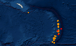
M 6.3 - South Sandwich Islands region​

https://earthquake.usgs.gov/earthquakes/eventpage/us6000f5h2/executive
  • 2021-08-13 10:34:29 (UTC)
  • 60.491°S 27.177°W
  • 10.0 km depth
This one is relatively shallow, and it's near the intersection of the Antarctic, Scotia (and Sandwich) and South American plates.
https://en.wikipedia.org/wiki/Scotia_Plate
https://en.wikipedia.org/wiki/Antarctic_Plate
https://en.wikipedia.org/wiki/South_American_Plate

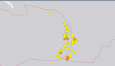
Another 30 aftershocks including the 6.3 Mag since my previous post.

All aftershocks between 7.5 and 6.3 Mag in format: Mag, Date/Time, Depth

5.1 2021-08-13 03:11:18 (UTC-07:00) 10.0 km
5.0 2021-08-13 02:01:24 (UTC-07:00) 35.0 km
5.1 2021-08-13 01:46:29 (UTC-07:00) 53.5 km
5.2 2021-08-13 01:33:13 (UTC-07:00) 10.0 km
5.0 2021-08-13 01:25:00 (UTC-07:00) 54.8 km
5.0 2021-08-13 00:13:56 (UTC-07:00) 37.1 km
5.2 2021-08-13 00:08:37 (UTC-07:00) 10.0 km
5.2 2021-08-13 00:04:34 (UTC-07:00) 10.0 km
5.0 2021-08-12 23:41:46 (UTC-07:00) 66.8 km
5.0 2021-08-12 23:34:34 (UTC-07:00) 10.0 km
5.5 2021-08-12 23:14:11 (UTC-07:00) 10.0 km
5.1 2021-08-12 22:44:04 (UTC-07:00) 45.3 km
5.0 2021-08-12 22:41:24 (UTC-07:00) 45.8 km
5.5 2021-08-12 22:24:58 (UTC-07:00) 31.6 km
5.3 2021-08-12 22:24:04 (UTC-07:00) 58.7 km
5.3 2021-08-12 21:53:09 (UTC-07:00) 10.0 km
5.1 2021-08-12 21:03:58 (UTC-07:00) 10.0 km
5.1 2021-08-12 20:53:21 (UTC-07:00) 35.0 km
5.7 2021-08-12 20:43:19 (UTC-07:00) 66.2 km
5.1 2021-08-12 20:38:23 (UTC-07:00) 10.0 km
4.6 2021-08-12 19:57:27 (UTC-07:00) 10.0 km
5.2 2021-08-12 19:33:40 (UTC-07:00) 10.0 km
4.9 2021-08-12 19:29:33 (UTC-07:00) 25.4 km
5.3 2021-08-12 18:47:37 (UTC-07:00) 10.0 km
4.9 2021-08-12 18:39:15 (UTC-07:00) 46.1 km
5.0 2021-08-12 18:26:41 (UTC-07:00) 31.1 km
4.6 2021-08-12 18:08:59 (UTC-07:00) 10.0 km
5.1 2021-08-12 17:46:19 (UTC-07:00) 10.0 km
5.0 2021-08-12 17:42:25 (UTC-07:00) 10.0 km
5.1 2021-08-12 17:04:15 (UTC-07:00) 10.0 km
5.4 2021-08-12 16:50:11 (UTC-07:00) 10.0 km
5.0 2021-08-12 16:32:56 (UTC-07:00) 19.9 km
5.4 2021-08-12 16:24:27 (UTC-07:00) 51.0 km
5.2 2021-08-12 16:23:45 (UTC-07:00) 52.9 km
4.9 2021-08-12 16:20:03 (UTC-07:00) 35.0 km
5.0 2021-08-12 16:08:13 (UTC-07:00) 35.0 km
4.8 2021-08-12 16:07:41 (UTC-07:00) 35.0 km
4.9 2021-08-12 15:40:01 (UTC-07:00) 35.0 km
4.9 2021-08-12 15:19:11 (UTC-07:00) 35.0 km
5.1 2021-08-12 15:13:10 (UTC-07:00) 35.0 km
5.5 2021-08-12 15:08:35 (UTC-07:00) 35.0 km
5.1 2021-08-12 14:56:55 (UTC-07:00) 10.0 km
5.1 2021-08-12 14:48:23 (UTC-07:00) 60.7 km
4.9 2021-08-12 14:25:14 (UTC-07:00) 35.0 km
5.2 2021-08-12 14:19:55 (UTC-07:00) 35.0 km
5.6 2021-08-12 14:07:01 (UTC-07:00) 69.3 km
5.2 2021-08-12 13:49:54 (UTC-07:00) 51.9 km
5.4 2021-08-12 13:38:07 (UTC-07:00) 69.6 km
5.3 2021-08-12 13:36:23 (UTC-07:00) 65.2 km
5.0 2021-08-12 13:28:40 (UTC-07:00) 60.1 km
5.4 2021-08-12 13:15:17 (UTC-07:00) 35.0 km
5.0 2021-08-12 13:14:45 (UTC-07:00) 35.0 km
5.8 2021-08-12 13:06:37 (UTC-07:00) 76.4 km
4.9 2021-08-12 13:05:00 (UTC-07:00) 10.0 km
5.5 2021-08-12 12:58:58 (UTC-07:00) 10.0 km
6.2 2021-08-12 12:44:55 (UTC-07:00) 61.9 km
6.0 2021-08-12 12:43:49 (UTC-07:00) 67.7 km
5.1 2021-08-12 12:39:22 (UTC-07:00) 10.0 km
5.7 2021-08-12 12:29:14 (UTC-07:00) 48.0 km
5.9 2021-08-12 12:07:52 (UTC-07:00) 18.9 km
5.9 2021-08-12 11:49:54 (UTC-07:00) 47.3 km
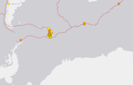
And this just in

M 5.8 - South Sandwich Islands region​

https://earthquake.usgs.gov/earthquakes/eventpage/us6000f5i9/executive
  • 2021-08-13 11:45:39 (UTC)
  • 57.285°S 25.558°W
  • 43.8 km depth
 
Well, very interesting developments for this sequence
The USGS have determined there were 2 separate quakes just under 3 minutes apart ...

M 8.1 - South Sandwich Islands region​

  • 2021-08-12 18:35:20 (UTC)
  • 58.416°S 25.321°W
  • 48.3 km depth
Seismic observations suggest this earthquake is part of a complex seismic sequence. Our current interpretation is that this earthquake is the mainshock to a M7.5 that occurred ~170s earlier. The location, depth, mechanism, and magnitude of this earthquake is preliminary and less well constrained than typical events of this size due to interference from the preceding M7.5 foreshock. Research is being conducted on this sequence to better understand the faulting geometry and details of rupture. This analysis will take time and our understanding will likely evolve. This page will be updated as we learn more about these interesting events.
https://earthquake.usgs.gov/earthquakes/eventpage/us6000f53e/executive

This does help to explain the VERY active aftershock sequence. And it also explains why I got around 30 mins or so of
wall to wall signal from what was initially listed as a single Mw7.5 event.
 
  • Wow
  • Informative
Likes   Reactions: Astronuc and Bystander
Comparing the 7.5 location and depth: 57.596°S 25.187°W, 63.3 km depth
with the Mag 8.1 location and depth: 58.416°S 25.321°W, 48.3 km depth

Distance
56.963 statute mi​
49.499 naut mi​
91.673 km​
ellipsoidal earth
Distance calculator: https://stevemorse.org/nearest/distance.php

The latter quake was not quite on top of the other, and it was shallower.
 
  • Like
Likes   Reactions: davenn
Astronuc said:
The latter quake was not quite on top of the other, and it was shallower.

Yes, about 100 - 120 km south of the M7.5
 
Vanadium 50 said:
I had no idea how far the Sandwich Islands are from the South Sandwich Islands. (My geography stinks) 8500 miles.
In my opinion, that's more history than geography -- Sandwich was a patron of Captain Cook, who named an achipelago of islands that he had discovered after him -- they later became called the Hawaiian Islands -- the Brits also named the (now uninhabited) South Sandwich Islands after him -- I think that neither set of islands, nor the familiar food assemblage, should ever have been named after him.
 
  • Like
  • Informative
Likes   Reactions: BillTre, Astronuc and davenn
  • #11
  • #12
Astronuc said:
M 6.9 - 136 km SE of Perryville, Alaska

Yes, recorded that one reasonably well

210814  UT Mw6.9 Alaskan ashk1.gif


but it hadnt event tailed off properly when the 7.2 hit and then the 7.2 totally overrode the 6.9 in amplitude ...

210814  UT Mw6.9 Alaskan ashk 7.2 Haiti.gif
Dave
 
  • #13
  • Like
Likes   Reactions: davenn
  • #14
Astronuc said:
Still strong activity in the area

yup and a 6.9 on the 16th ... recorded that one quite well
 
  • #16
As of Friday, ongoing aftershocks in the 4.7-5.2 Mag range

5.2 2021-08-20 08:56:51 (UTC-07:00) 12.7 km
5.1 2021-08-20 08:07:47 (UTC-07:00) 56.8 km
4.8 2021-08-20 04:16:16 (UTC-07:00) 21.7 km
5.2 2021-08-19 20:41:22 (UTC-07:00) 80.9 km
5.1 2021-08-19 20:21:33 (UTC-07:00) 35.0 km
5.1 2021-08-19 20:13:51 (UTC-07:00) 10.0 km
4.7 2021-08-19 19:42:30 (UTC-07:00) 28.6 km
5.0 2021-08-19 18:09:51 (UTC-07:00) 10.0 km
5.1 2021-08-19 14:26:32 (UTC-07:00) 10.0 km

And the magnitudes don't appear to be diminishing in intensity after one week, although they seem to diminish in frequency.
 
  • #18
Another couple of large aftershocks from the South Sandwich Islands

M 6.8 - South Sandwich Islands region​

  • 2021-08-22 00:45:08 (UTC)
  • 60.122°S 24.344°W
  • 11.0 km depth

M 7.1 - South Sandwich Islands region​

  • 2021-08-22 21:33:20 (UTC)
  • 60.291°S 24.895°W
  • 14.0 km depth

Mw6.8 and Mw7.1

2108122  UT M6.8 and 7.1 ashks South Sandwich Isl2.gif
 
  • #19
davenn said:
Another couple of large aftershocks from the South Sandwich Islands
I was wondering if we might see another in the 7 Mag range, and 6.8 was close.

I was looking at events in the region. I grabbed a couple of screenshots of the earthquakes over 7 days ending yesterday. The 7.1 and 6.8 are at the lower right of the group, near the triple intersection.
 

Attachments

  • SouthSandwichIslands_2021-08-23 Latest Earthquakes(last7days).png
    SouthSandwichIslands_2021-08-23 Latest Earthquakes(last7days).png
    12.8 KB · Views: 198
  • SouthSandwichIslands_Region_2021-08-23 Earthquakes(last7days).png
    SouthSandwichIslands_Region_2021-08-23 Earthquakes(last7days).png
    9.4 KB · Views: 204
Last edited:
  • Like
Likes   Reactions: davenn
  • #20
Still activity in the South Sandwich Islands, and some isolated tremors along the Antarctic Plate boundary
Code:
5.0  South Sandwich Islands region  2021-08-29 07:53:24 (UTC-07:00)  48.3 km
4.7  Southwest Indian Ridge         2021-08-29 07:13:12 (UTC-07:00)  10.0 km
4.9  South Sandwich Islands region  2021-08-29 06:04:04 (UTC-07:00)  41.4 km
5.3  southwest of Africa            2021-08-28 21:01:18 (UTC-07:00)  10.0 km
4.9  South Shetland Islands         2021-08-28 16:08:55 (UTC-07:00)  14.9 km
5.1  South Sandwich Islands region  2021-08-28 13:10:11 (UTC-07:00)  50.6 km
 

Attachments

  • Earthquakes_08302021_South Sandwich Islands and Antarctic Plate(last7days).png
    Earthquakes_08302021_South Sandwich Islands and Antarctic Plate(last7days).png
    15.2 KB · Views: 179
  • Like
Likes   Reactions: davenn

Similar threads

Replies
1
Views
2K
  • · Replies 8 ·
Replies
8
Views
3K
  • · Replies 2 ·
Replies
2
Views
3K
Replies
1
Views
2K
  • · Replies 1 ·
Replies
1
Views
2K
  • · Replies 1 ·
Replies
1
Views
2K
Replies
0
Views
2K
  • · Replies 2 ·
Replies
2
Views
2K
  • · Replies 5 ·
Replies
5
Views
4K
Replies
5
Views
2K