Over 6,000
aftershocks have been recorded following the massive quake as of 11am local time, the Philippine Institute of Volcanology and Seismology (Phivolcs) said on Monday.
. . . .
Residents reported a geological phenomenon known as “coastal uplift” after the quake, with the shoreline extending by as much as 200 metres in many places.
During the
earthquake, the Cotabato trench off the southwestern coast of Philippines “pushed part of the coastlines of Sarangani and Davao [provinces]” and exposed the seabed that was originally submerged, Phivolcs said.
The seabed uplift has been estimated to be about 2 metres.
“Preliminary field observations indicate approximately 2 metres of coastal uplift and about 200 metres of shoreline retreat,” Phivolcs said.
In several regions, “formerly submerged corals are now exposed”, the agency said, adding that coastal landslides were also observed between the municipalities of Barangays Burias and Glan in Sarangani.
Images released by Phivolcs show large numbers of corals, seagrass, dead fish and other aquatic life on the exposed seafloor.
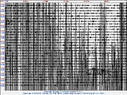 260607 2337UT M7.8 offshr sthrn tip of Mindanao zhi.gif264.2 KB · Views: 3
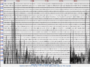 260607 2337UT M7.8 offshr sthrn tip of Mindanao zlo1.gif188 KB · Views: 4
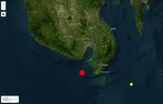 20260607 2337UT M7.8 ofshr sthrn tip of Mindanao, Phils1.webp38.3 KB · Views: 1
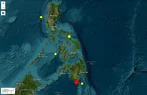 20260607 2337UT M7.8 ofshr sthrn tip of Mindanao, Phils2.webp62.3 KB · Views: 4