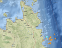
M6.8 and M6.3 east of Mindanao, Philippines

  • Thread starter Thread starter Astronuc
  • Start date Start date
  • Tags Tags
    Earthquake
AI Thread Summary
A magnitude 6.8 earthquake occurred 18 km ENE of Barcelona, Philippines, followed by a 6.3 magnitude quake 36 km E of the same location, with no tsunami warning issued. The earthquakes were at depths of 25.8 km and 15.9 km, respectively, with several smaller quakes in the M4.4 to M5.3 range reported in the area. The absence of a tsunami warning indicates no significant underwater displacement occurred that could generate a tsunami. The discussion highlights that earthquakes of magnitude 7.5 or higher are typically required to trigger tsunami alerts. Overall, the seismic activity is attributed to thrust faulting, which is less likely to cause tsunamis compared to other fault types.
Astronuc
Staff Emeritus
Science Advisor
Gold Member
Messages
22,340
Reaction score
7,138

M 6.8 - 18 km ENE of Barcelona, Philippines​

(was reported initially as M6.7)
https://earthquake.usgs.gov/earthquakes/eventpage/us6000nhqc/executive
  • 2024-08-02 22:23:01 (UTC)
  • 8.193°N 126.600°E
  • 25.8 km depth

M 6.3 - 36 km E of Barcelona, Philippines​

https://earthquake.usgs.gov/earthquakes/eventpage/us6000nht0/executive
  • 2024-08-03 04:20:26 (UTC)
  • 8.170°N 126.764°E
  • 15.9 km depth

Many smaller earthquakes in the vicinity in the M4.4 to M5.3 range. No tsunami warning issued.

https://www.voanews.com/a/magnitude-earthquake-hits-off-philippines-mindanao-island/7728430.html
 

Attachments

  • M6.8_Mindanao_08022024.png
    M6.8_Mindanao_08022024.png
    174.1 KB · Views: 55
Earth sciences news on Phys.org
A "no tsunami warning issued" means there was no activity in the water to be concerned about, such as an underwater earthquake or a landslide into the water, right?
 
jedishrfu said:
A "no tsunami warning issued" means there was no activity in the water to be concerned about, such as an underwater earthquake or a landslide into the water, right?
Right, there would have been no significant displacement of a volume of earth (subsea surface) and/or volume of water. The displacement could have been lateral, instead of vertical, and there was no apparent underwater slide, or if there was, it was away from Mindanao.

Maybe @davenn can comment.
 
I also found that the issuing authority might also decide to issue a warning under the following conditions:

1. Detection of an Undersea Earthquake: A warning may be issued if an undersea earthquake of significant magnitude (typically 7.5 or higher) is detected, particularly in areas known for producing tsunamis.

2. Unusual Sea Level Changes: If significant and unusual sea-level changes are observed, such as rapid rises or falls, this may indicate that a tsunami has been generated, and a warning will be issued.

3. Reports of Tsunami Activity: Credible reports of tsunami activity, such as from coastal residents, ships, or buoys, can trigger a tsunami warning.

4. Confirmation from Tsunami Detection Systems: Tsunami detection systems, such as deep-ocean buoys or coastal tide gauges, can confirm the presence of a tsunami. If these systems detect a tsunami, a warning will be issued.

5. Historical Data and Tsunami Models: If the conditions match those of previous events that have produced tsunamis and models predict a potential tsunami, authorities may issue a warning.
 
Astronuc said:
. The displacement could have been lateral, instead of vertical, and there was no apparent underwater slide, or if there was, it was away from Mindanao.

Maybe @davenn can comment.

jedishrfu said:
1. Detection of an Undersea Earthquake: A warning may be issued if an undersea earthquake of significant magnitude (typically 7.5 or higher) is detected, particularly in areas known for producing tsunamis.

hi guys,
yes, tho this was a thrust fault, which are the ones that cause most tsunamis, at M6.8, it's well below the magnitude of what would normally cause a tsunami. below the "beachball focal mechanism for the 6.8
main shock. It is mostly thrust ( reverse faulting) with a very small component of strike-slip. Hence why the blue area is offset vertically. With north at the top, the thrust direction was to the WNW ( roughly in a line between the P and the T.


1723599108770.png


That M7.5 mentioned above is a pretty good guideline for quake size and tsunami generation.

I only recall one M7 quake that produced a significant tsunami. It was on the north coast of New Guinea
On July 17, 1998, a 7.0 magnitude (Mw) earthquake struck the island of Papua New Guinea at 5:49 p.m.
local time.
PNG quake and tsunami

With an up to 15m of run-up. It has been suggested, for various reasons, that the 7.0 triggered an
under-sea land slide that caused a large water colum offset to produce the tsunami.
That article covers it well.

cheers
Dave
 
  • Like
Likes Astronuc and jedishrfu
On August 10, 2025, there was a massive landslide on the eastern side of Tracy Arm fjord. Although some sources mention 1000 ft tsunami, that height represents the run-up on the sides of the fjord. Technically it was a seiche. Early View of Tracy Arm Landslide Features Tsunami-causing slide was largest in decade, earthquake center finds https://www.gi.alaska.edu/news/tsunami-causing-slide-was-largest-decade-earthquake-center-finds...
Hello, I’m currently writing a series of essays on Pangaea, continental drift, and Earth’s geological cycles. While working on my research, I’ve come across some inconsistencies in the existing theories — for example, why the main pressure seems to have been concentrated in the northern polar regions. So I’m curious: is there any data or evidence suggesting that an external cosmic body (an asteroid, comet, or another massive object) could have influenced Earth’s geology in the distant...
Back
Top