M7.5 Earthquake, near Anamizu, W Japan

  • Thread starter Thread starter Astronuc
  • Start date Start date
  • Tags Tags
    Earthquake Japan
Click For Summary
SUMMARY

A magnitude 7.5 earthquake struck near Anamizu, Japan, at 4:10 p.m. local time on January 1, 2024, with a depth of 10 kilometers (6 miles), according to the United States Geological Survey (USGS). The epicenter was located approximately 42 kilometers (26 miles) northeast of Anamizu on the Noto Peninsula. Following the main quake, an aftershock of magnitude 6.2 occurred 46 kilometers to the south-southwest. Tsunami warnings were issued, and significant damage was reported, including building collapses and land uplift along the coast, extending the shoreline by up to 250 meters (820 feet).

PREREQUISITES
  • Understanding of seismic activity and earthquake measurement scales (e.g., Richter scale, moment magnitude scale).
  • Familiarity with tsunami warning systems and emergency response protocols.
  • Knowledge of geological processes such as land uplift and its implications.
  • Awareness of the geographical context of Japan, particularly the Noto Peninsula and Ishikawa Prefecture.
NEXT STEPS
  • Research the Japan Meteorological Agency's earthquake monitoring and tsunami warning systems.
  • Study the geological implications of land uplift following seismic events.
  • Examine case studies of earthquake damage assessments and recovery efforts in Japan.
  • Learn about the historical seismic activity in the Noto Peninsula region.
USEFUL FOR

This discussion is beneficial for geologists, emergency management professionals, urban planners, and anyone interested in earthquake preparedness and response strategies in seismically active regions.

Astronuc
Staff Emeritus
Science Advisor
Gold Member
2025 Award
Messages
22,498
Reaction score
7,419
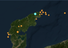
An earthquake struck at 4:10 p.m. local time at a depth of 10 kilometers (6 miles), around 42 kilometers (26 miles) northeast of Anamizu in Ishikawa prefecture, according to the United States Geological Survey (USGS).

M 7.5 - 42 km NE of Anamizu, Japan​

https://earthquake.usgs.gov/earthquakes/eventpage/us6000m0xl/executive
  • 2024-01-01 07:10:09 (UTC)
  • 37.498°N 137.242°E
  • 10.0 km depth
Some strong aftershocks expected, and tsunami warning issued. The M7.5 was followed by an M6.2 about 46 km to the SSW. Several aftershocks were reported in the M4.5 to 5.6 range

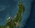
M 6.2 - 4 km SSW of Anamizu, Japan​

https://earthquake.usgs.gov/earthquakes/eventpage/us6000m0xm/executive
  • 2024-01-01 07:18:42 (UTC)
  • 37.196°N 136.870°E
  • 10.0 km depth
https://www.msn.com/en-us/news/worl...-earthquake-strikes-western-japan/ar-AA1miqGr
Japanese officials issued tsunami and evacuation warnings after a powerful earthquake struck the west coast on Monday afternoon.

An earthquake with a preliminary magnitude of 7.5 struck at about 4:10 p.m. local time, with its epicenter on the Noto Peninsula, along the Sea of Japan, according to U.S. Geological Survey data.

The Japan Meteorological Agency said it measured the quake at a preliminary magnitude at 7.6, adding there had also been more than a dozen smaller ones, including aftershocks.
 

Attachments

  • M7-5_Anamizu,Japan_2024-01-01.png
    M7-5_Anamizu,Japan_2024-01-01.png
    44 KB · Views: 134
  • M7-5_Anamizu,W_Honshu,Japan_2024-01-01.png
    M7-5_Anamizu,W_Honshu,Japan_2024-01-01.png
    105.4 KB · Views: 134
  • Like
Likes   Reactions: davenn
Earth sciences news on Phys.org
Yikes. Looks like a fair amount of damage...
 
berkeman said:
Yikes. Looks like a fair amount of damage...
Apparently, some homes/buildings collapsed. With a M7.5, I'd expect a lot of damage near the epicenter, which was on land, as were the majority of aftershocks.

Anamizu is a town located in Hōsu District, Ishikawa Prefecture, Japan, on the Noto Peninsula.
https://en.wikipedia.org/wiki/Noto_Peninsula
https://en.wikipedia.org/wiki/Anamizu,_Ishikawa

https://www.msn.com/en-us/news/worl...-causing-tsunami-and-killing-four/ar-AA1mitxS
A video shows some damage.

https://www.msn.com/en-us/news/worl...dings-along-japan-s-western-coast/ar-AA1mkmPU
 
Last edited:
Geologist's explanation of this earthquake

 
Space photos show Japan's 7.6-magnitude earthquake lifted land out of the sea, extending parts of its coastline by as much as 2 football fields
https://www.msn.com/en-us/news/worl...e-by-as-much-as-2-football-fields/ar-AA1mwKG3

  • The quake raised land along the coast, extending the coastline by up to [250 m, or] 820 feet, in some places
In other words, the seashore (beaches) are extended further outward. Navigation charts would seemingly need updating.
Preliminary satellite analysis and on-the-ground surveys have found that the earthquake raised land along the coast — a process called uplift — by as much as 4 meters, roughly 13 feet.

Some media are reporting M7.6 vs M7.5.
 
  • Wow
Likes   Reactions: berkeman and dlgoff

Similar threads

  • · Replies 1 ·
Replies
1
Views
3K
Replies
1
Views
753
Replies
5
Views
3K
  • · Replies 6 ·
Replies
6
Views
3K
Replies
5
Views
1K
  • · Replies 5 ·
Replies
5
Views
576
  • · Replies 4 ·
Replies
4
Views
3K
  • · Replies 4 ·
Replies
4
Views
4K
  • · Replies 2 ·
Replies
2
Views
3K
  • · Replies 2 ·
Replies
2
Views
2K