M 7.7 Quake, Indonesia

  • Thread starter Thread starter davenn
  • Start date Start date
Join the discussion
Registration is free. Ask a follow-up in this thread, or start your own.
8 replies · 1K views
Science Advisor
Gold Member
Messages
9,742
Reaction score
11,957
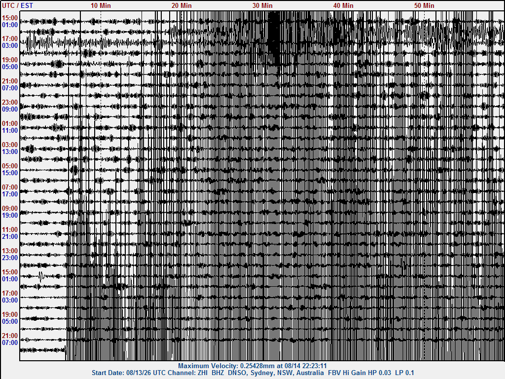
Another large quake on my seismo ( In Sydney, Australia) this morning ....

260814 2158UT M7.7 Indonesia zhi.gif


Saved image before the trace started overwriting itself ... that's 55 minutes of recording shown

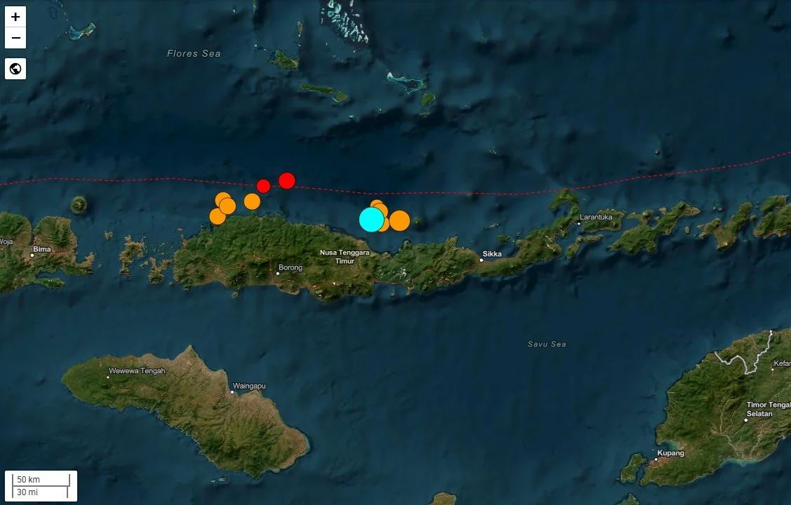
M 7.7 - 68 km NNW of Ende, Indonesia​

  • 2026-08-14 21:58:21 (UTC)
  • 8.310°S 121.352°E
  • 10.0 km depth

This is the 11th M 7.0 - 7.9 for the year and we are half way through August.
So far, the numbers are trending about normal for the annual average of 18 / year.

M7.0 - 7.9's / year range from around 12 to 25 or around 1 every 20 days.
That allows for any approx. 6 more M7 events over the next 4 months till the end of the year
and still be at the annual average.

260814 2158UT M7.7 Indonesia map.webp


cheers
Dave
 
Reply
  • Wow
  • Informative
Likes   Reactions: Astronuc and ohwilleke
Earth sciences news on Phys.org
davenn said:
Another large quake on my seismo ( In Sydney, Australia) this morning ....

View attachment 373626


Saved image before the trace started overwriting itself ... that's 55 minutes of recording shown

M 7.7 - 68 km NNW of Ende, Indonesia​

  • 2026-08-14 21:58:21 (UTC)
  • 8.310°S 121.352°E
  • 10.0 km depth

This is the 11th M 7.0 - 7.9 for the year and we are half way through August.
So far, the numbers are trending about normal for the annual average of 18 / year.

M7.0 - 7.9's / year range from around 12 to 25 or around 1 every 20 days.
That allows for any approx. 6 more M7 events over the next 4 months till the end of the year
and still be at the annual average.

View attachment 373627


cheers
Dave
Dang. What would the tsunami risk for these quakes be? I see a city named Sikka near the coast. Is the water deep enough to be conducive for tsunami formation? Hopefully, people and buildings are safe.
 
Reply
  • Like
Likes   Reactions: ohwilleke and WWGD
AlexB23 said:
What would the tsunami risk for these quakes be?
It depends on the type of quake. Where there is a rapid or significant upheaval (vertical displacement) of the ocean floor, as happened off the coast of Japan in the Great Tohoku earthquake, a significant tsunami threat results. Lateral displacements without significant vertical displacement do not produce strong tsunami.

In the current case, there was no significant tsunami: "A tsunami with a maximum height of 1.61 m (5 ft 3 in) was reported in Reok, Manggarai Regency. A 0.94 m (3 ft 1 in) tsunami was recorded at Maurole District in Ende Regency while at Labuan Bajo in East Nusa Tenggara, a 30 cm (12 in) tsunami was recorded. A 0.17 m (6.7 in) tsunami occurred in Dompu."
https://en.wikipedia.org/wiki/2026_Flores_earthquake#Tsunami

https://earthquake.usgs.gov/earthquakes/eventpage/us6000tkt2/executive
The August 14, 2026, M7.7 Flores Sea earthquake occurred off the northern coast of East Nusa Tenggara, Indonesia, as the result of reverse faulting at shallow depth. The earthquake is located in a seismically active area dominated by convergence between the Australia and Sunda plates. Focal mechanism solutions indicate that the rupture occurred on either a west-striking fault dipping moderately to the north or an east-striking fault dipping shallowly to the south. The location, depth, and preliminary focal mechanism solution for this earthquake indicate the event is likely the result of thrust faulting within the overriding Sunda plate. At the location of this earthquake, the Australian plate is moving towards the north with respect to the Sunda plate at approximately 69 mm/yr. These two plates meet at the Sunda Trench, located approximately 350 km south of this earthquake.

While commonly plotted as points on maps, earthquakes of this size are more appropriately described as slip over a larger fault area. Reverse-faulting events of the size of the August 14, 2026, earthquake are typically about 90 by 45 km in size (length x width).

Earthquakes are common in this region. Since 1950, there have been 37 other earthquakes of magnitude 6 and greater, including five other earthquakes of magnitude 7 and larger within 250 km of the August 14, 2026, earthquake. In 1992, a M7.8 earthquake occurred just 63 km east-southeast of the August 14, 2026, earthquake. The 1992 earthquake and resulting tsunami destroyed tens of thousands of homes and resulted in at least 2500 fatalities.

There may be conditions (certain geometries, e.g., a bay) where a strike-slip fault may cause a significant tsunami.
Anatomy of strike-slip fault tsunami genesis
https://www.pnas.org/doi/10.1073/pnas.2025632118

Contrary to Previous Belief, Strike-Slip Faults Can Generate Large Tsunamis (May 03, 2021)
https://www.caltech.edu/about/news/...trike-slip-faults-can-generate-large-tsunamis
On September 28, 2018, an inexplicably large tsunami devastated the Indonesian coastal city of Palu and several others nearby. Between the tsunami and the magnitude 7.5 earthquake that caused it, some 4,340 people were killed, making it the deadliest earthquake that year.
https://en.wikipedia.org/wiki/2018_Sulawesi_earthquake_and_tsunami#Tsunami
Residents of Donggala were told to expect tsunamis with heights of 0.5 to 3 metres, while residents in Palu were told to expect tsunamis with heights of less than 0.5 metres. The tsunami, however, struck higher than expected. Residents of Palu reported waves with heights of more than 2 metres while several others stated that the waves managed to reach the second floor.
 
Reply
  • Informative
  • Like
Likes   Reactions: davenn, berkeman and AlexB23
Astronuc said:
It depends on the type of quake. Where there is a rapid or significant upheaval (vertical displacement) of the ocean floor, as happened off the coast of Japan in the Great Tohoku earthquake, a significant tsunami threat results. Lateral displacements without significant vertical displacement do not produce strong tsunami.

In the current case, there was no significant tsunami: "A tsunami with a maximum height of 1.61 m (5 ft 3 in) was reported in Reok, Manggarai Regency. A 0.94 m (3 ft 1 in) tsunami was recorded at Maurole District in Ende Regency while at Labuan Bajo in East Nusa Tenggara, a 30 cm (12 in) tsunami was recorded. A 0.17 m (6.7 in) tsunami occurred in Dompu."
https://en.wikipedia.org/wiki/2026_Flores_earthquake#Tsunami

https://earthquake.usgs.gov/earthquakes/eventpage/us6000tkt2/executive


There may be conditions (certain geometries, e.g., a bay) where a strike-slip fault may cause a significant tsunami.
Anatomy of strike-slip fault tsunami genesis
https://www.pnas.org/doi/10.1073/pnas.2025632118

Contrary to Previous Belief, Strike-Slip Faults Can Generate Large Tsunamis (May 03, 2021)
https://www.caltech.edu/about/news/...trike-slip-faults-can-generate-large-tsunamis

https://en.wikipedia.org/wiki/2018_Sulawesi_earthquake_and_tsunami#Tsunami
No tsunami. That is all I needed to know, which means less damage and loss of life.
 
AlexB23 said:
No tsunami.
Careful. In the current case, there was no significant tsunami: "A tsunami with a maximum height of 1.61 m (5 ft 3 in) was reported in Reok, Manggarai Regency. A 0.94 m (3 ft 1 in) tsunami was recorded at Maurole District in Ende Regency while at Labuan Bajo in East Nusa Tenggara, a 30 cm (12 in) tsunami was recorded. A 0.17 m (6.7 in) tsunami occurred in Dompu."
There were minor tsunami waves, with one recorded at 1.61 m, or 5.25 ft.

It was the nature of the type of earthquake and it's location (in relatively shallow water), and even though it was Mag 7.7, the tsunami waves were considered minor.


There have been at least 70 aftershocks (Mag 4 to 6.1) along the fault line since the Mag 7.7.
 
Reply
  • Like
Likes   Reactions: davenn and AlexB23
Astronuc said:
There were minor tsunami waves, with one recorded at 1.61 m, or 5.25 ft.

It was the nature of the type of earthquake and it's location (in relatively shallow water), and even though it was Mag 7.7, the tsunami waves were considered minor.


There have been at least 70 aftershocks (Mag 4 to 6.1) along the fault line since the Mag 7.7.
All is good then. Phew
 
Reply
  • Like
Likes   Reactions: berkeman
The earthquake has been upgraded to 7.8
Regional information - https://earthquake.usgs.gov/earthquakes/eventpage/us7000tgrk/region-info

M 7.8 - 64 km NNW of Ende, Indonesia​

https://earthquake.usgs.gov/earthquakes/eventpage/us6000tkt2/executive
  • 2026-08-14 21:58:21 (UTC)
  • 8.351°S 121.348°E
  • 10.0 km depth
Two subsequent earthquakes occurred along the same subduction zone.

M 6.9 - 9 km WNW of Pematangsiantar, Indonesia​

in Sumatera Utara province
  • 2026-08-15 10:54:51 (UTC)
  • 2.986°N 98.985°E
  • 175.0 km depth
and more recently

M 6.5 - 126 km NNE of Teluknaga, Indonesia​

north of Jakarta (137.1 km (85.2 mi) )
  • 2026-09-11 21:23:55 (UTC)
  • 4.983°S 106.874°E
  • 372.0 km depth
During this period 6 volcanoes erupted (as of August 31)

1. Mount Semeru (East Java)​

Indonesia’s tallest volcano on Java erupted several times beginning around 4.20am on 31 August, producing ash columns between 500 and 900 metres above the summit.

2. Mount Ibu (North Maluku)​

Mount Ibu on Halmahera Island was arguably the busiest volcano of the day.

It erupted multiple times from just after midnight until the afternoon, with ash plumes reaching 400–600 metres above the crater.

3. Mount Anak Krakatau (Sunda Strait)​

The most famous volcano on this list didn’t stop erupting after August 31.

Anak Krakatau produced a much larger eruption several days later, sending ash as high as 15 kilometres into the atmosphere.

The eruption forced the temporary closure of eight Indonesian airports, disrupted more than 1,500 flights, and affected roughly 170,000 passengers. Schools in parts of Indonesia also switched to online learning due to ash fall.

4. Mount Sinabung (North Sumatra​

Sinabung produced the largest ash plume of the six volcanoes, blasting volcanic material approximately 3,500 metres above its summit.

The eruption was significant enough for authorities to raise the volcano’s alert level and advise residents to stay at least six kilometres away. Ash also blanketed nearby roads and villages, with protective masks distributed to residents.

5. Mount Ili Lewotolok (East Nusa Tenggara)​

Located on Lembata Island, Ili Lewotolok erupted late in the morning, producing a 700-metre ash column drifting westward.

While smaller than Sinabung’s eruption, it remains one of eastern Indonesia’s regularly active volcanoes and is continuously monitored for lava, ash and lahar hazards.

It later erupted again last Sunday morning (6 September), sending up a plume of smoke and ash up to 400 metres.

6. Mount Lewotobi Laki-laki (East Flores)​

The sixth volcano erupted shortly before 1pm, sending a 300-metre grey ash plume towards the west and northwest.

Lewotobi Laki-laki has been closely watched since its major eruptions over the past two years, with surrounding communities remaining on alert for renewed volcanic activity.

Ref: Six Indonesian Volcanoes Erupted On 31 August, And They’re Still Erupting Indonesia sits along the Pacific Ring of Fire, where as many as 120 volcanoes are active.
https://www.therakyatpost.com/news/...1-august-and-theyre-still-erupting/#gsc.tab=0

On September 7, Indonesia reported volcanic eruption at Anak Krakatau is easing but keeps airports and schools closed


(Monday, September 7) Indonesia kept several airports closed and shifted schools to remote learning Monday after a volcano erupted Sunday. The continuous, 25-hour eruption of Anak Krakatau that produced a fountain of lava and a boom heard 700 kilometers (435 miles) away ended Sunday, the country's Geological Agency said. But it remained active Monday with moderate, intermittent eruptions, dark ash emissions and small, localized earthquakes, the agency said in a statement. Weather was obscuring visual observations of the eruption.The volcanic island of Anak Krakatau, located in Indonesia’s Sunda Strait between the main Java and Sumatra islands, had shown signs of activity since Friday before erupting for 30 seconds at 3:53 a.m. Sunday and for 16 seconds about three hours later, Indonesia’s Geological Agency said. Closed-circuit camera footage showed lava flares from the volcano.
 
Last edited:
Reply
  • Like
Likes   Reactions: davenn
Astronuc said:

3. Mount Anak Krakatau (Sunda Strait)​

The most famous volcano on this list didn’t stop erupting after August 31.

Anak Krakatau produced a much larger eruption several days later, sending ash as high as 15 kilometres into the atmosphere.

I would really love to travel there and record this volcano doing its thing
 
Reply
  • Like
Likes   Reactions: Astronuc
davenn said:
I would really love to travel there and record this volcano doing its thing
There may be more opportunities to see it erupting
https://en.wikipedia.org/wiki/Anak_Krakatoa#2020s

Apparently, a lot of folks want to visit it, but authorities warn people to keep a distance. I'm sure there is a concern that it could explosively erupt.