Major Tropical Cyclone NE Australia

6 replies · 4K views · last reply
Science Advisor
Gold Member
Messages
9,757
Reaction score
12,033
Cyclone Debbie is a major CAT 4 storm at the time it hit the Queensland coast in the Bowen area. It has sustained winds near the centre of 185 kilometres per hour with wind gusts to 260 km/hr have been recorded.
The Bureau of Meteorology (Australian weather service) suggest the possibility that gusts could exceed 270 km/hr near the eye.
High storm surges have already been recorded along the coast.
The storm is expected to deteriorate quickly after it is over land and away from the warm tropical seas.

Satellite image at 1200 hrs AEST ( Australian Eastern Standard Time), 28th March 2017

Satellite image of Cyclone Debbie over northeast Australia, showing a large spiral storm with a clear eye above the Queensland coastline and dark ocean to the east. Timestamp: Tuesday, 28 March 2017, 01:00 pm AEDT.


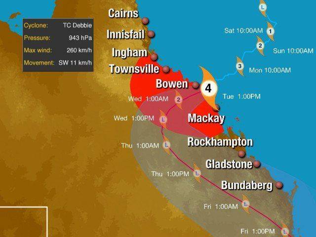
Forecast track map of Tropical Cyclone Debbie off northeast Queensland, with red shaded wind-impact area, a panel showing pressure 943 hPa, max wind 260 km/h, movement SW 11 km/h, and timed track markers from Sat 10:00AM to Fri 1:00PM past Bowen, Mackay, Rockhampton, Gladstone and Bundaberg.
it's a bit more than 1500km north of my location

Dave
 
ohhh and a weather radar that includes lightning data

Weather radar map of northeast Queensland, Australia, with green and yellow rainfall returns forming a large spiral around Bowen, with town labels and a timestamp reading Tue 12:00 EST.
 
  • Like
Likes   Reactions: SW VandeCarr
OmCheeto said:
Is it safe to assume you missed the "900 mm" rainstorm?

fortunately ! ... we have had quite a bit of rain in my region recently, but nothing like what they have had up north because of the cyclone

... the cyclone has been gone for almost a week but there are still areas going under flood waters up north because it has taken time for all the water in the tributaries to make it down into the main river course and cause it to flood the main river through the city of Rockhampton is a one of those and by lunch time tomorrow it is expected to peak at approx. 9 metres above normal level

Dave
 
Last edited:
  • Like
Likes   Reactions: OmCheeto
davenn said:
fortunately ! ... we have had quite a bit of rain in my region recently, but nothing like what they have had up north because of the cyclone

... the cyclone has been gone for almost a week but there are still areas going under flood waters up north because it has taken time for all the water in the
tributaries to make it down into the main river course and cause it to flood
the main river through the city of Rockhampton is a one of those and by lunch time tomorrow it is expected to peak at approx. 9 metres above normal level

Dave
It's hard for me to imagine that much rain, in such a short period of time, as that's approximately our annual average here: 915 mm
 
OmCheeto said:
It's hard for me to imagine that much rain, in such a short period of time, as that's approximately our annual average here: 915 mm
It took some time for me to find a link, I was trying to get my head around how much rain fell compared to what happened near my location a few years ago... 19" in six hours :wideeyed:
http://blogs.wsj.com/numbers/how-much-rain-fell-in-marble-falls-texas-138/

The 900mm was spread out for 48 hours, but still "when you are flooded, you are flooded" :frown: