Kruidnootje
- 24
- 0
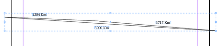
I plotted 3 points on Google Earth.
West (point A) to slightly North point (point B)= 1284 Km A-B
From Point B to further East Point (point C) = 1717 Km
Then a straight direct line from point C back to point A
The Perimeter = 6001 Km
Area = 57 491 Km
Angle A = 1.711 degrees
Angle B = 177.01 degrees
Angle C = 1.279 degrees
(sorry can't find any degree sign symbol on the right)
Problem:
When I drop a perpendicular line down from Angle B to the longest line (3000) the height is 18 Km
When I calculate by using the formula h = 57491/1500 = 38.33 Km
Is the discrepancy caused by the curvature of the Earth on Google maps? Can one even form an accurate triangular representation in this manner?