MHB How do I divide my land into 3 equal parts?

  • Thread starter Thread starter getrichschemer
  • Start date Start date
AI Thread Summary
The discussion centers on dividing a property into three equal parts after concerns about incorrect survey markers. The original poster seeks guidance on measuring distances from the road to accurately separate the land. Participants note that additional information, such as bearings and angles, is necessary to resolve the issue effectively. A rough calculation suggests marking off approximately 241 feet from the northwest corner towards the road to achieve one-third of the land area. The conversation emphasizes the importance of precise measurements and the need for right angles in the division process.
getrichschemer
Messages
3
Reaction score
0
I hope this isn't the wrong forum to post this. Thanks in advance!

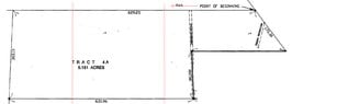
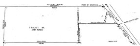
I purchased this property and hired someone to survey the property, but the markers they put out seem wrong. I'm not a math expert but maybe someone here can help me figure out where the markers are supposed to be. How many feet from right to left do I walk into the property from the road. I need to separate it in 3 equal parts. See the image for illustration.

Thank you!View attachment 397
 

Attachments

  • DIVIDED.jpg
    DIVIDED.jpg
    30.8 KB · Views: 121
Mathematics news on Phys.org
Why do you suspect the markers are wrong? Did you already pay the surveyor?

It appears to me there is not quite enough information.

1) One measurement is missing, but that might be okay if we could fix the other problem.
2) Some bearing would be nice. Which way is north? Are the horizontal(ish) lines parallel? What are the angles from the mostly horizontal lines to the more vertical lines?

Just measuring the sides of a polygon with more than three sides does not a complete determination make.
 
tkhunny said:
Why do you suspect the markers are wrong? Did you already pay the surveyor?

It appears to me there is not quite enough information.

1) One measurement is missing, but that might be okay if we could fix the other problem.
2) Some bearing would be nice. Which way is north? Are the horizontal(ish) lines parallel? What are the angles from the mostly horizontal lines to the more vertical lines?

Just measuring the sides of a polygon with more than three sides does not a complete determination make.
We are also given the area (but it still looks like harder work than it need be).

If that is a scale diagram I would recommend squaring it up and counting squares ... (It won't give the answer to 5 significant digits or even 2 decimal places in feet, but then I doubt that the dimensions are really that accurate anyway)

CB
 
Last edited:
tkhunny said:
Why do you suspect the markers are wrong? Did you already pay the surveyor?

It appears to me there is not quite enough information.

1) One measurement is missing, but that might be okay if we could fix the other problem.
2) Some bearing would be nice. Which way is north? Are the horizontal(ish) lines parallel? What are the angles from the mostly horizontal lines to the more vertical lines?

Just measuring the sides of a polygon with more than three sides does not a complete determination make.

Ive attached the original image.
View attachment 399
 

Attachments

  • plattmod.jpg
    plattmod.jpg
    48.5 KB · Views: 104
I would ask the surveyor one thing, actually.

Why is WY 347 bearing 71º37'53" going North but 71º37'54" going South?

This immediately introduces error. It's not a whole inch over 345.30 ft, but it is error.
 
Ok so how do I figure out how many feet from right to left do I walk? Divided into 3 equal parts or really close?
 
Okay, here's your rough calculation, but you should pay me at least half what you paid the surveyor. I'll take the drawing to mean that east and west are parallel to the horizontal members (North is up!). Obviously, this is not the case for the real world, but it will do.

We are totally in luck that the horizontal members appear to be parallel. This simplifies the task considerably.

Starting on the left of your drawing and using the bearings provided, that SW angle is 87.32º.

Walking east until the NW corner is directly above you, we manage to move only 14.174 ft.

If we then connect this point to the NW Corner, we find this distance to be 302.80 ft.

The trick is, then, to draw another line, parallel to the one we just drew, but farther to the East, so that we contain 1/3 of your 5.181 acres.

A little algebra: 302.80\cdot\frac{n + (n+14.174)}{2} = 75228 \implies n = 241.35 ft

In other words, if you start at the NW Corner, and mark off 241 ft toward the road, then make a right turn (90º) to the southern boundary, you will have marked off very close to 1/3 of the land.

If we do this again, from the line just established, it is easier because it is rectangular and not trapezoidal. In this case, 302.80\cdot m = 75228 \implies m = 248.44 ft. This should be a little more because you don't have that odd little triangle on the West end.

With a little luck, 829.25 - 241.35 - 248.44 = 339.46 is your answer. I'm a little worried that this is so close to the drainage ditch, but you're not paying me enough to spend any more time on this. Suffice it to say that if 339½ ft from the road puts you West of the drainage ditch, you're good. You will have to figure out how to make right angles since I mostly mentioned measurements along the Northern boundary. Translating them to the Southern boundary can be accomplished a couple of ways.

Well, good luck with that. I was just in Wyoming, but we mostly stayed on I-80.
 
Back
Top