catmitt98
- 6
- 0
I am trying to calculate closing speeds for airplane traffic. I am using the formula found here--
https://mathhelpboards.com/calculus-10/calculate-closing-velocities-19402.html
The question I have is about whether or not I can use wgs-84 coordinates for x and y positions for the planes. Basically, I am given a bearing for each plane in degrees, a velocity for each plane in knots, and the wgs-84 latitude/longitude positions, recorded in radians.
I know I can find the x and y velocities by using xvel = sin(bearing(PI/180))*velocity and yvel = cos(bearing(PI/180))*velocity but I'm not sure how to get an x and y position in correct units from latitude/longitude given in radians. I'd need some way to convert radians to nautical miles so that I'd have position in nautical miles, and velocity in nautical miles/hour (knots), but is this possible?
Right now I am converting the radians to degrees, degrees to semi-circle, semi-circle to meters, and meters to nautical miles. (complicated, I know).
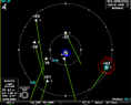
When calculating an absolute distance between the two planes, this conversion seems to be accurate. But, when trying to find the x and y values using the latitude and longitude, the x values (longitude * conversion) are too large, and the y values (latitude * conversion) are too small. For example, the straight line distance between the plane circled in blue and the plane circled in red is being calculated as 5.81 nautical miles, which looks accurate. But, x and y positions of the traffic circled in red are being calculated as (+7.4nm, -0.23nm) relative to the one circled in blue, when it should clearly be closer to (+5.9, -2.3). This is causing the closure rate being calculated as positive 43 knots, when in reality it should be negative, as the traffic circled in red is moving 136 knots, and the traffic circled in blue is moving 230 knots.
https://www.physicsforums.com/attachments/9169._xfImport
Is there any reliable way to turn latitude/longitude positions given in radians into nautical miles?
I can post the code I have if needed, but the code is executing the math correctly. It just seems that the conversion from longtitude/latitude in radians to nautical miles is incorrect :/
**As a side note, the definition for semi-circle units can be found here: https://docs.microsoft.com/en-us/previous-versions/windows/embedded/cc510650(v=msdn.10)
https://mathhelpboards.com/calculus-10/calculate-closing-velocities-19402.html
The question I have is about whether or not I can use wgs-84 coordinates for x and y positions for the planes. Basically, I am given a bearing for each plane in degrees, a velocity for each plane in knots, and the wgs-84 latitude/longitude positions, recorded in radians.
I know I can find the x and y velocities by using xvel = sin(bearing(PI/180))*velocity and yvel = cos(bearing(PI/180))*velocity but I'm not sure how to get an x and y position in correct units from latitude/longitude given in radians. I'd need some way to convert radians to nautical miles so that I'd have position in nautical miles, and velocity in nautical miles/hour (knots), but is this possible?
Right now I am converting the radians to degrees, degrees to semi-circle, semi-circle to meters, and meters to nautical miles. (complicated, I know).
When calculating an absolute distance between the two planes, this conversion seems to be accurate. But, when trying to find the x and y values using the latitude and longitude, the x values (longitude * conversion) are too large, and the y values (latitude * conversion) are too small. For example, the straight line distance between the plane circled in blue and the plane circled in red is being calculated as 5.81 nautical miles, which looks accurate. But, x and y positions of the traffic circled in red are being calculated as (+7.4nm, -0.23nm) relative to the one circled in blue, when it should clearly be closer to (+5.9, -2.3). This is causing the closure rate being calculated as positive 43 knots, when in reality it should be negative, as the traffic circled in red is moving 136 knots, and the traffic circled in blue is moving 230 knots.
https://www.physicsforums.com/attachments/9169._xfImport
Is there any reliable way to turn latitude/longitude positions given in radians into nautical miles?
I can post the code I have if needed, but the code is executing the math correctly. It just seems that the conversion from longtitude/latitude in radians to nautical miles is incorrect :/
**As a side note, the definition for semi-circle units can be found here: https://docs.microsoft.com/en-us/previous-versions/windows/embedded/cc510650(v=msdn.10)