Hurricane Florence (and Michael) Reports

  • Thread starter Thread starter Greg Bernhardt
  • Start date Start date
  • Tags Tags
    Hurricane
AI Thread Summary
Hurricane Florence has made landfall near Wilmington, North Carolina, with maximum sustained winds of 105 mph and significant flooding reported in the area. The storm's outer bands have already impacted parts of North Carolina, leading to evacuations and warnings of up to 17 cubic miles of rain expected across the Carolinas. In upstate South Carolina, conditions remain mostly sunny, but heavy rain and strong winds are anticipated over the weekend. Reports indicate that while some areas are experiencing severe weather, others are seeing minimal impact, with power outages and debris noted but no major damage. The storm is expected to continue moving northwest, bringing rain and flooding to various regions over the coming days.
Messages
19,787
Reaction score
10,739
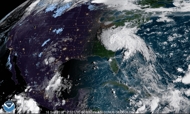
Stay safe PFers in the area. We know there are many of you. Reports are the outer bands have just hit NC and there is already flooding.
https://weather.com/
 
Physics news on Phys.org
Track the storm(s) - https://www.nhc.noaa.gov/

SUMMARY OF 1100 AM EDT...1500 UTC...INFORMATION
-----------------------------------------------
LOCATION...33.4N 75.5W
ABOUT 145 MI...230 KM ESE OF WILMINGTON NORTH CAROLINA
ABOUT 195 MI...315 KM E OF MYRTLE BEACH SOUTH CAROLINA
MAXIMUM SUSTAINED WINDS...105 MPH...165 KM/H
PRESENT MOVEMENT...NW OR 315 DEGREES AT 10 MPH...17 KM/H
MINIMUM CENTRAL PRESSURE...955 MB...28.20 INCHES

I have friends and colleagues in the Wilmington and Cape Fear area. Some family members are further west in Charlotte. Like so many, I'm waiting and watching.
 
Here in upstate (northwest) SC it's mostly sunny right now, and is supposed to stay that way today, with breezes. Tomorrow (Saturday), the wind is supposed to pick up, and rain will start late in the day. Sunday will be the big day here: 30-35 mph winds with higher gusts, and 6-8 inches of rain. Not nearly as bad as on the coast, of course. We'll probably have some falling trees and power outages.

In this town we shouldn't have major flooding because there are no rivers or extreme terrain. We're on a low ridge between watersheds, and all the streams flow away from town. One of them runs behind the houses on the other side of our street, and our house is about 20-25 feet above it.

The college down the street where I used to work has canceled classes for today and Monday. I think it's mainly because many students are from storm-affected areas and want to be able to go home to help out. Administrative and service staff are still supposed to come to work if they can do so safely.
 
  • Like
Likes dlgoff, Astronuc and Greg Bernhardt
Just got back from my morning walk. Cloudy, cool, breezy with occasional gusts, occasional very light sprinkles of rain, not worth opening the umbrella for. We must have had some stronger gusts overnight, which left some leaves, twigs and small branches on the ground.
 
  • Like
Likes Greg Bernhardt
jtbell said:
Here in upstate (northwest) SC it's mostly sunny right now, and is supposed to stay that way today, with breezes. Tomorrow (Saturday), the wind is supposed to pick up, and rain will start late in the day.
SUMMARY OF 1100 AM EDT...1500 UTC...INFORMATION
-----------------------------------------------
LOCATION...33.6N 79.6W
ABOUT 40 MI...65 KM W OF MYRTLE BEACH SOUTH CAROLINA
ABOUT 40 MI...65 KM S OF FLORENCE SOUTH CAROLINA
MAXIMUM SUSTAINED WINDS...45 MPH...75 KM/H
PRESENT MOVEMENT...W OR 270 DEGREES AT 2 MPH...4 KM/H
MINIMUM CENTRAL PRESSURE...995 MB...29.38 INCHESIt looks like the center of the storm will move into NW SC by 8 am tomorrow and pass slowly through the region, then up through the NC/TN border on Sunday, along the Appalachian range WV, eastern KY by Monday, OH river valley, through PA and S NY (Tuesday) into New England through Wednesday. Lots of rain and flooding along the way for the next several days.

Meanwhile, Storm Helene will likely become an extra-tropical storm or cyclone this weekend or early next week. It is predicted to travel through Ireland and Scotland during Monday/Tuesday..
https://www.nhc.noaa.gov/mobile/refresh/MIATCDAT3+html/MIATCDAT3_151435.html
 
Last edited:
Checking in from Durham NC. Looks like we escape the worst of the weather. A few bursts of torrential rain amidst periodic showers. Some gusty winds but nothing that sustained. Power went out for about an hour and a half last afternoon/evening, but came back on... probably just a blown transformer.

Took a bike ride out this afternoon. Wet, yucky and a lot of tree branches and like debris, but nothing too tragic looking. Seems we just got scraped by the edge of the storm, but lots of rain to come over the next few days.

diogenesNY
 
  • Like
Likes Greg Bernhardt
It looks like we dodged the bullet, too. The center of the tropical depression passed over us around 8 AM, more or less. We've had a fairly steady light rain with gusty breezes since early yesterday afternoon, but I've seen no major downpours. There are small puddles of water on the street outside. We haven't lost electricity in our neighborhood, don't know about other areas around here yet. Most of the action in upstate SC seems to be northeast of the I-26 corridor, up towards Charlotte.

However, southeast NC is still getting a lot of rain, with moisture still streaming in from the Atlantic. The news reports from Wilmington, New Bern and Jacksonville are pretty alarming. Rivers are still rising. Further inland, Fayetteville (IIRC) has ordered evacuations from within a mile of its river(s).
 
  • Like
Likes Greg Bernhardt
upload_2018-9-16_11-57-55.png


From, http://www.intellicast.com/National/Precipitation/Weekly.aspx?location=USVA0659
 

Attachments

  • upload_2018-9-16_11-57-55.png
    upload_2018-9-16_11-57-55.png
    102.3 KB · Views: 414
  • #10
Waiting patiently for any rain to start in the DC metro area, looks like we will get some later tonight thru Monday. As for amounts, it is hovering in the 1 inch total for the event as opposed to the 8-10 inches predicted early last week.
 
  • #12
Looks like we dodged a bullet again. The center of the remnants of Hurricane Michael passed west of Columbia SC and east of us this morning. Most of the rain is on the east side of the storm, i.e. the opposite side from us, from Columbia towards the coast. We got a good soaking rain overnight and early this morning. Now it's mostly stopped, or maybe just paused. Not too much wind, as far as I can tell. The sun is supposed to come out by evening.

Most or all of the schools in the area, including the college, closed as a precaution. That's a third day off, after two days for Florence.

It's amazing how much faster all this has been happening, compared to Florence.
 
  • Like
Likes berkeman and Greg Bernhardt
Back
Top